File:NERC-map-en.svg
Jump to navigation
Jump to search

Size of this PNG preview of this SVG file: 600 × 600 pixels. Other resolutions: 240 × 240 pixels | 480 × 480 pixels | 768 × 768 pixels | 1,024 × 1,024 pixels | 2,048 × 2,048 pixels | 1,730 × 1,730 pixels.
Original file (SVG file, nominally 1,730 × 1,730 pixels, file size: 272 KB)
Captions
Captions
Add a one-line explanation of what this file represents
Summary[edit]

|
This file requires updating because: Southwest Power Pool extends from Canada to Texas In doing so, you could add a timestamp to the file.
|
| Description |
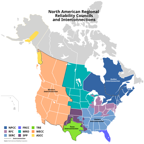
English: English version of a map showing the Regional Reliability Councils and Interconnections in North America.
Based on File:BlankMap-USA-states-Canada-provinces,_HI_closer.svg by Lokal Profil, CC-BY-SA 2.5, File:Nercmap.JPG by J JMesserly PD-Self Data Source: North American Reliability CorporationFrançais : Version anglaise d'une carte montrant les Conseils régionaux de fiabilité et les interconnexions de l'Amérique du Nord.
Basé sur File:BlankMap-USA-states-Canada-provinces,_HI_closer.svg par Lokal Profil, CC-BY-SA 2.5, File:Nercmap.JPG par J JMesserly PD-lui-même Source des données : North American Reliability Corporation |
| Date | |
| Source | Own work |
| Author | Bouchecl |
| Other versions | Version française |
This W3C-unspecified vector image was created with Inkscape .
Licensing[edit]
I, the copyright holder of this work, hereby publish it under the following license:
This file is licensed under the Creative Commons Attribution-Share Alike 3.0 Unported license.
- You are free:
- to share – to copy, distribute and transmit the work
- to remix – to adapt the work
- Under the following conditions:
- attribution – You must give appropriate credit, provide a link to the license, and indicate if changes were made. You may do so in any reasonable manner, but not in any way that suggests the licensor endorses you or your use.
- share alike – If you remix, transform, or build upon the material, you must distribute your contributions under the same or compatible license as the original.
File history
Click on a date/time to view the file as it appeared at that time.
| Date/Time | Thumbnail | Dimensions | User | Comment | |
|---|---|---|---|---|---|
| current | 03:58, 11 May 2009 | | 1,730 × 1,730 (272 KB) | Bouchecl (talk | contribs) | {{Information |Description={{en|1=English version of a map showing the Regional Reliability Councils and Interconnections in North America. Based on File:BlankMap-USA-states-Canada-provinces,_HI_closer.svg by Lokal Profil, CC-BY |
You cannot overwrite this file.
File usage on Commons
The following 2 pages use this file:
File usage on other wikis
The following other wikis use this file:
- Usage on ca.wikipedia.org
- Usage on de.wikipedia.org
- Usage on en.wikipedia.org
- Usage on fr.wikipedia.org
- Usage on ru.wikipedia.org