File:NEC map.svg
Jump to navigation
Jump to search

Size of this PNG preview of this SVG file: 781 × 599 pixels. Other resolutions: 313 × 240 pixels | 626 × 480 pixels | 1,001 × 768 pixels | 1,280 × 982 pixels | 2,560 × 1,964 pixels | 1,676 × 1,286 pixels.
Original file (SVG file, nominally 1,676 × 1,286 pixels, file size: 264 KB)
Captions
Captions
Add a one-line explanation of what this file represents
| Description |
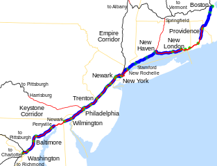
Map of the Northeast Corridor, traced on USGS topos. Legend:
|
||
| Date | |||
| Source | Own work; USGS topographic maps | ||
| Author | User:SPUI | ||
| Permission (Reusing this file) |
|
| This work has been released into the public domain by its author, SPUI. This applies worldwide. In some countries this may not be legally possible; if so: |
File history
Click on a date/time to view the file as it appeared at that time.
| Date/Time | Thumbnail | Dimensions | User | Comment | |
|---|---|---|---|---|---|
| current | 02:45, 23 April 2012 | | 1,676 × 1,286 (264 KB) | Pi.1415926535 (talk | contribs) | Wickford Junction service begins tomorrow! |
| 03:35, 13 July 2011 |  | 1,676 × 1,286 (263 KB) | Pi.1415926535 (talk | contribs) | MBTA Commuter Rail to T.F. Green. | |
| 20:59, 19 March 2007 |  | 1,676 × 1,286 (257 KB) | NE2 (talk | contribs) | Oops... I forgot to crop it. | |
| 20:56, 19 March 2007 |  | 1,898 × 1,711 (243 KB) | NE2 (talk | contribs) | Changed the color in Massachusetts to reflect the state ownership. | |
| 03:12, 25 October 2005 |  | 1,676 × 1,286 (239 KB) | SPUI~commonswiki (talk | contribs) | fixed text placement | |
| 03:08, 25 October 2005 |  | 1,676 × 1,286 (235 KB) | SPUI~commonswiki (talk | contribs) | {{spuimap}} Map of the Northeast Corridor, traced on USGS topos. category:railroad maps category:Amtrak Category:Pennsylvania Railroad Category:New York, New Haven and Hartford Railroad |
You cannot overwrite this file.
File usage on Commons
The following 2 pages use this file:
File usage on other wikis
The following other wikis use this file:
- Usage on cs.wikipedia.org
- Usage on da.wikipedia.org
- Usage on de.wikipedia.org
- Usage on en.wikipedia.org
- Usage on es.wikipedia.org
- Usage on fa.wikipedia.org
- Usage on fr.wikipedia.org
- Usage on hu.wikipedia.org
- Usage on id.wikipedia.org
- Usage on it.wikipedia.org
- Usage on ja.wikipedia.org
- Usage on ko.wikipedia.org
- Usage on nl.wikipedia.org
- Usage on no.wikipedia.org
- Usage on pt.wikipedia.org
- Usage on vi.wikipedia.org
- Usage on www.wikidata.org
- Usage on zh.wikipedia.org