File:NATO vs Warsaw (1949-1990).png
Jump to navigation
Jump to search

Size of this preview: 800 × 210 pixels. Other resolutions: 320 × 84 pixels | 1,248 × 327 pixels.
Original file (1,248 × 327 pixels, file size: 18 KB, MIME type: image/png)
Captions
Captions
Add a one-line explanation of what this file represents

|
This military map image could be re-created using vector graphics as an SVG file. This has several advantages; see Commons:Media for cleanup for more information. If an SVG form of this image is available, please upload it and afterwards replace this template with
{{vector version available|new image name}}.
It is recommended to name the SVG file “NATO vs Warsaw (1949-1990).svg”—then the template Vector version available (or Vva) does not need the new image name parameter. |
Summary[edit]
.png&action=edit§ion=1)
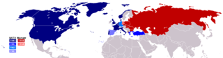
English: Border of NATO and Warsaw Pact in contrast to each other from 1949 (formation of NATO) to 1990 (withdrawal of East Germany)
Based on Image:Map of Warsaw Pact countries.png, Image:Map of NATO countries.png, Image:NATO expansion.png


Licensing[edit]
.png&action=edit§ion=2)

|
Permission is granted to copy, distribute and/or modify this document under the terms of the GNU Free Documentation License, Version 1.2 or any later version published by the Free Software Foundation; with no Invariant Sections, no Front-Cover Texts, and no Back-Cover Texts. A copy of the license is included in the section entitled GNU Free Documentation License. |
| This file is licensed under the Creative Commons Attribution-Share Alike 3.0 Unported license. | ||
| ||
| This licensing tag was added to this file as part of the GFDL licensing update. |
Lexus Gordon
File history
Click on a date/time to view the file as it appeared at that time.
.png&dir=prev)
.png&offset=20060731161128)
.png&offset=&limit=20)
.png&offset=&limit=50)
.png&offset=&limit=100)
.png&offset=&limit=250)
.png&offset=&limit=500)
| Date/Time | Thumbnail | Dimensions | User | Comment | |
|---|---|---|---|---|---|
| current | 17:14, 24 March 2016 | 1,248 × 327 (18 KB) | Jhertel (talk | contribs) | Corrected colors for 1952 and 1955 which were swapped on the map. The map showed Germany as joining in 1952, and Greece and Turkey as joining in 1952, both of which is untrue according to English Wikipediaː "In 1952, Greece and Turkey became members o... | |
| 07:30, 18 July 2007 | 1,248 × 327 (29 KB) | Hoshie (talk | contribs) | added the Caribbean DOM-ROMs, Crown Dependencies aren't in the UK. Under same lic. as original. | ||
| 23:08, 9 April 2007 | 1,248 × 327 (19 KB) | Aivazovsky~commonswiki (talk | contribs) | |||
| 22:20, 28 November 2006 | 1,164 × 344 (31 KB) | Hoshie (talk | contribs) | Transfer from en.wiki: Made Eritrea a part of Ethiopia; added YAR and PDRY to map. under same license as original | ||
| 19:50, 25 November 2006 | 1,158 × 344 (32 KB) | IAMTHEEGGMAN (talk | contribs) | |||
| 23:29, 22 November 2006 | 1,277 × 344 (30 KB) | とある白い猫 (talk | contribs) | Reverted to earlier revision | ||
| 16:43, 31 July 2006 |  | 839 × 564 (31 KB) | とある白い猫 (talk | contribs) | changing order | |
| 16:38, 31 July 2006 |  | 839 × 599 (33 KB) | とある白い猫 (talk | contribs) | trying something new | |
| 16:17, 31 July 2006 | 1,158 × 344 (28 KB) | とある白い猫 (talk | contribs) | slicing warsaw pact a bit | ||
| 16:11, 31 July 2006 | 1,277 × 344 (30 KB) | とある白い猫 (talk | contribs) | fixing greendland |
You cannot overwrite this file.
File usage on Commons
There are no pages that use this file.
File usage on other wikis
The following other wikis use this file:
- Usage on vi.wikipedia.org
.png&oldid=690423266)