File:NASA Spacecraft Views Erupting Chilean Volcano.jpg

Original file (2,200 × 900 pixels, file size: 233 KB, MIME type: image/jpeg)
Captions
Captions
Summary[edit]
| Description |
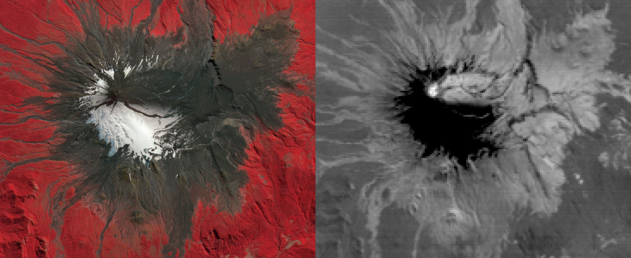
English: On March 3, 2015, Chile's Villarrica volcano erupted, forcing the evacuation of thousands of people. The eruption deposited a layer of ash over the volcano's eastern slope, blanketing and darkening the normal winter snow cover. The eruption and its effects were captured by the Advanced Spaceborne Thermal Emission and Reflection Radiometer (ASTER) instrument on NASA's Terra spacecraft on March 9. Black flows on the other flanks are mud and ash flows. Vegetation is displayed in red colors. The thermal infrared image shows hot spots (white colored) at the summit crater, indicating continuing volcanic activity. The ash blanket is warmer (brighter) than the cold snow (black). The image covers an area of 13.5 by 16.5 kilometers, and is located at 39.4 degrees south, 71.9 degrees west.
With its 14 spectral bands from the visible to the thermal infrared wavelength region and its high spatial resolution of 15 to 90 meters (about 50 to 300 feet), ASTER images Earth to map and monitor the changing surface of our planet. ASTER is one of five Earth-observing instruments launched Dec. 18, 1999, on Terra. The instrument was built by Japan's Ministry of Economy, Trade and Industry. A joint U.S./Japan science team is responsible for validation and calibration of the instrument and data products. The broad spectral coverage and high spectral resolution of ASTER provides scientists in numerous disciplines with critical information for surface mapping and monitoring of dynamic conditions and temporal change. Example applications are: monitoring glacial advances and retreats; monitoring potentially active volcanoes; identifying crop stress; determining cloud morphology and physical properties; wetlands evaluation; thermal pollution monitoring; coral reef degradation; surface temperature mapping of soils and geology; and measuring surface heat balance. The U.S. science team is located at NASA's Jet Propulsion Laboratory, Pasadena, Calif. The Terra mission is part of NASA's Science Mission Directorate, Washington, D.C Image Details Mission: Terra Target: Earth Spacecraft: Terra Instrument: Advanced Spaceborne Thermal Emission and Reflection Radiometer (ASTER) |
| Date | |
| Source | http://www.jpl.nasa.gov/spaceimages/images/largesize/PIA19241_hires.jpg |
| Author | NASA/GSFC/METI/ERSDAC/JAROS, and U.S./Japan ASTER Science Team |
Licensing[edit]
| This file is in the public domain in the United States because it was solely created by NASA. NASA copyright policy states that "NASA material is not protected by copyright unless noted". (See Template:PD-USGov, NASA copyright policy page or JPL Image Use Policy.) | ||
 |
Warnings:
|
File history
Click on a date/time to view the file as it appeared at that time.
| Date/Time | Thumbnail | Dimensions | User | Comment | |
|---|---|---|---|---|---|
| current | 06:05, 4 May 2015 | 2,200 × 900 (233 KB) | LuisArmandoRasteletti (talk | contribs) | NASA Spacecraft Views Erupting Chilean Volcano | |
| 06:03, 4 May 2015 | 2,077 × 850 (245 KB) | LuisArmandoRasteletti (talk | contribs) | User created page with UploadWizard |
You cannot overwrite this file.
File usage on Commons
There are no pages that use this file.