File:Myanmar Railways stations map (composite).jpg
Jump to navigation
Jump to search

Size of this preview: 206 × 599 pixels. Other resolutions: 82 × 240 pixels | 165 × 480 pixels | 264 × 768 pixels | 352 × 1,024 pixels | 704 × 2,048 pixels | 8,860 × 25,748 pixels.
Original file (8,860 × 25,748 pixels, file size: 89.58 MB, MIME type: image/jpeg)
Captions
Captions
Add a one-line explanation of what this file represents
| Warning | The original file is very high-resolution. It might not load properly or could cause your browser to freeze when opened at full size. |
|---|
| Description |
|
| Date | see file history |
| Source |
Own work using: |
| Author | Maximilian Dörrbecker (Chumwa) |
| Permission (Reusing this file) |
I, the copyright holder of this work, hereby publish it under the following license: This file is licensed under the Creative Commons Attribution-Share Alike 2.5 Generic license.
Sie dürfen das Bild zu den folgenden Bedingungen nutzen:
|
File history
Click on a date/time to view the file as it appeared at that time.
| Date/Time | Thumbnail | Dimensions | User | Comment | |
|---|---|---|---|---|---|
| current | 15:52, 26 May 2017 | 8,860 × 25,748 (89.58 MB) | Chumwa (talk | contribs) | ||
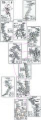
| 05:32, 26 May 2017 | 8,860 × 25,748 (89.16 MB) | Chumwa (talk | contribs) | {{Information |Description= *{{de|Karte der Bahnstationen in Myanmar: Zusammensetzung der Einzelkarten}} *{{en|Map of the railway stations of Myanmar: composite of the individual maps}} |Source={{Own using}} *[[:en:File:Myanmar Railways Division.png|Ov... |
You cannot overwrite this file.
File usage on Commons
The following 8 pages use this file:
- User:Chumwa/Gallery
- User:Chumwa/OgreBot/Potential transport maps/2017 May 21-31
- User:Chumwa/OgreBot/Public transport information/2017 May 21-31
- User:Chumwa/OgreBot/Transport Maps/2017 May 21-31
- User:Chumwa/OgreBot/Travel and communication maps/2017 May 21-31
- File:Myanmar Railways Division.png
- File:Myanmar Railways station map Division 1 Myitkyina.png
- File:Myanmar Railways station map Division 2 Ywa-Htaung.png
File usage on other wikis
The following other wikis use this file:
- Usage on en.wikipedia.org
- File:Myanmar RailWays Map Division 3 Mandalay.png
- File:Myanmar Railways station map Division 4 Kalaw.png
- File:Myanmar Railways station map Division 5 Taungoo.png
- File:Myanmar Railways station map Division 6 Yangon.png
- File:Myanmar Railways station map Division 7 Yangon.png
- File:Myanmar Railways station map Division 8 Mawlamyine.png
- File:Myanmar Railways station map Division 9 Hinthada.png
- File:Myanmar Railways station map Division 10 Pakokku.png
- File:Myanmar Railways station map Division 11 Bagan.png
.jpg&oldid=664138093)