File:Mt Vesuvius 79 AD eruption.svg
(Redirected from File:Mt Vesuvius 79 AD eruption 3.svg)

Size of this PNG preview of this SVG file: 800 × 482 pixels. Other resolutions: 320 × 193 pixels | 640 × 386 pixels | 1,024 × 617 pixels | 1,280 × 771 pixels | 2,560 × 1,542 pixels.
Original file (SVG file, nominally 800 × 482 pixels, file size: 87 KB)
Captions
Captions
Add a one-line explanation of what this file represents
Summary[edit]
| Description |
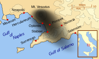
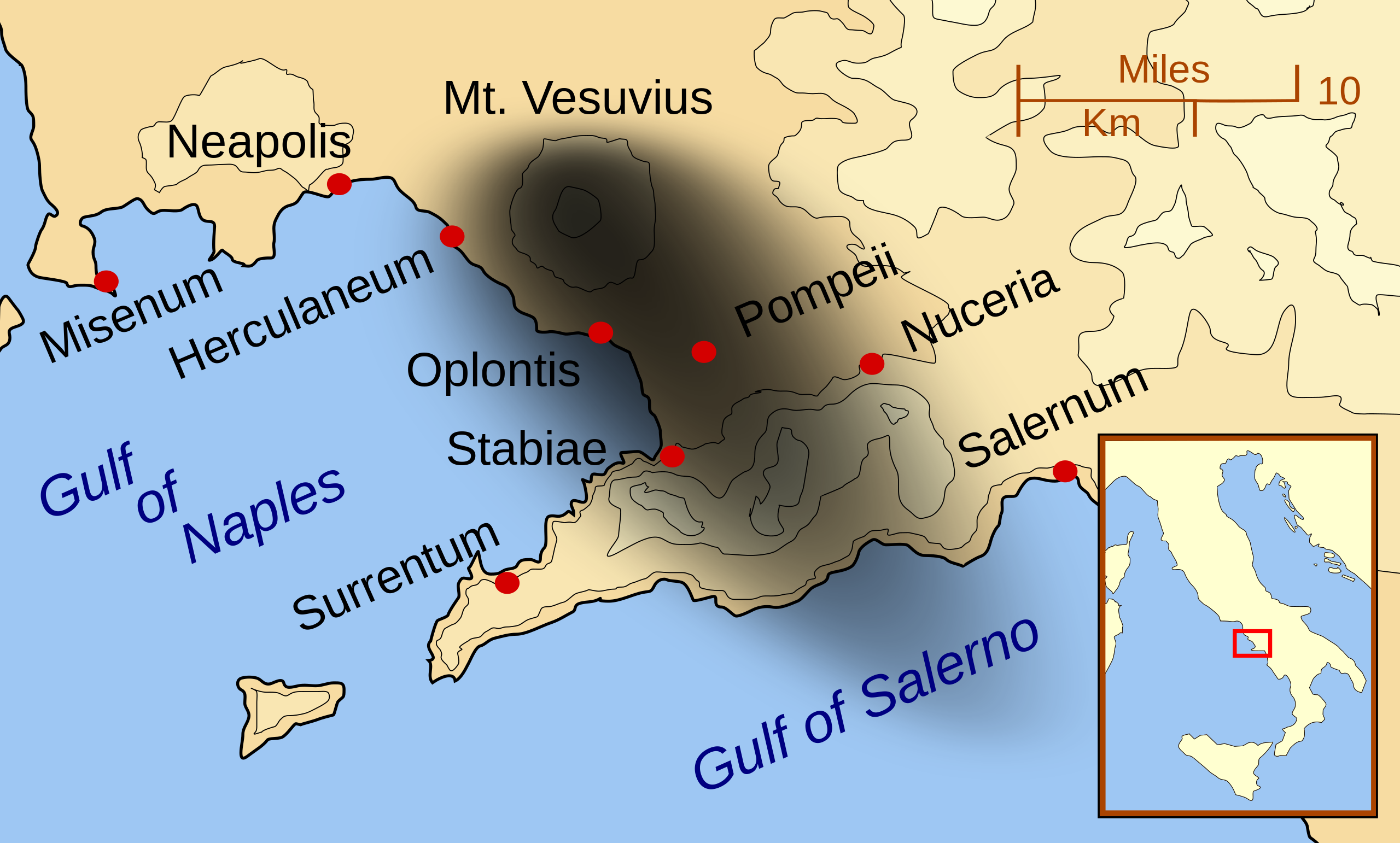
English: A map showing the cities and towns affected by the eruption of Mount Vesuvius in 79 AD. The general shape of the ash and cinder fall (see w:en:pyroclast) is shown by the dark area to the southeast of Mt Vesuvius. (P.S. It seems strange to show the modern day English names for the two bodies of water - I am open to suggestions).
This map shows lines and uses the Mercator projection (although that is not important on a map of this scale). North is, as usual, at the top of the map. |
| Date | |
| Source | Own work |
| Author | MapMaster |
| Other versions |
[]
|


|
This SVG file contains embedded text that can be translated into your language, using any capable SVG editor, text editor or the SVG Translate tool. For more information see: About translating SVG files. |
Licensing[edit]
I, the copyright holder of this work, hereby publish it under the following licenses:

|
Permission is granted to copy, distribute and/or modify this document under the terms of the GNU Free Documentation License, Version 1.2 or any later version published by the Free Software Foundation; with no Invariant Sections, no Front-Cover Texts, and no Back-Cover Texts. A copy of the license is included in the section entitled GNU Free Documentation License. |
This file is licensed under the Creative Commons Attribution-Share Alike 3.0 Unported, 2.5 Generic, 2.0 Generic and 1.0 Generic license.
- You are free:
- to share – to copy, distribute and transmit the work
- to remix – to adapt the work
- Under the following conditions:
- attribution – You must give appropriate credit, provide a link to the license, and indicate if changes were made. You may do so in any reasonable manner, but not in any way that suggests the licensor endorses you or your use.
- share alike – If you remix, transform, or build upon the material, you must distribute your contributions under the same or compatible license as the original.
You may select the license of your choice.
| Annotations | This image is annotated: View the annotations at Commons |
File history
Click on a date/time to view the file as it appeared at that time.
| Date/Time | Thumbnail | Dimensions | User | Comment | |
|---|---|---|---|---|---|
| current | 01:55, 24 February 2014 | | 800 × 482 (87 KB) | Ras67 (talk | contribs) | ditto |
| 01:42, 24 February 2014 |  | 644 × 388 (88 KB) | Ras67 (talk | contribs) | frame removed | |
| 01:07, 16 October 2007 |  | 652 × 396 (113 KB) | MapMaster (talk | contribs) | corrected mis-named Gulf of Salerno | |
| 04:02, 15 October 2007 |  | 652 × 396 (112 KB) | MapMaster (talk | contribs) | Dropped Title sqaure, and added towns and names of the 2 bays. | |
| 05:16, 14 October 2007 |  | 652 × 454 (126 KB) | MapMaster (talk | contribs) | Minor changes made after seeing how it's rendered by Wikimedia | |
| 05:11, 14 October 2007 |  | 355 × 247 (125 KB) | MapMaster (talk | contribs) | {{Information |Description=A map showing the cities and town affected by the eruption of Mount Vesuvius in 79 AD. The general shape of the ash and cinder fall is shown by the dark area to the southeast of Mt Vesuvious. |Source=self-made |Date=October 200 |
You cannot overwrite this file.
File usage on Commons
The following 23 pages use this file:
- User:MapMaster
- File:Mt Vesuvius 79 AD eruption-fr.svg
- File:Mt Vesuvius 79 AD eruption-he.svg
- File:Mt Vesuvius 79 AD eruption-la.svg
- File:Mt Vesuvius 79 AD eruption-mk.svg
- File:Mt Vesuvius 79 AD eruption-nl.svg
- File:Mt Vesuvius 79 AD eruption-ru.svg
- File:Mt Vesuvius 79 AD eruption.svg
- File:Mt Vesuvius 79 AD eruption 3.svg (file redirect)
- User:MapMaster
- File:Mt Vesuvius 79 AD eruption.svg
- File:Mt Vesuvius 79 AD eruption-la.svg
- File:Mt Vesuvius 79 AD eruption-he.svg
- File:Mt Vesuvius 79 AD eruption-nl.svg
- File:Mt Vesuvius 79 AD eruption-fr.svg
- File:Vesuvius 79 AD eruption Latina-pt.svg
- File:Mt Vesuvius 79 AD eruption-ru.svg
- Template:Other versions/Mt Vesuvius 79 AD eruption
- File:Mt Vesuvius 79 AD eruption ZH.svg
- File:Mt Vesuvius 79 AD eruption-mk.svg
- File:Mt Vesuvius 79 AD eruption ZH.svg
- File:Vesuvius 79 AD eruption Latina-pt.svg
- Template:Other versions/Mt Vesuvius 79 AD eruption
File usage on other wikis
The following other wikis use this file:
- Usage on ar.wikipedia.org
- Usage on bn.wikipedia.org
- Usage on ca.wikipedia.org
- Usage on cs.wikipedia.org
- Usage on da.wikipedia.org
- Usage on de.wikipedia.org
- Usage on el.wikipedia.org
- Usage on en.wikipedia.org
- Usage on eo.wikipedia.org
- Usage on es.wikipedia.org
- Usage on eu.wikipedia.org
- Usage on fa.wikipedia.org
- Usage on fi.wikipedia.org
- Usage on fr.wikipedia.org
- Usage on ga.wikipedia.org
- Usage on gl.wikipedia.org
- Usage on he.wikipedia.org
- Usage on hr.wikipedia.org
- Usage on hu.wikipedia.org
- Usage on hyw.wikipedia.org
- Usage on id.wikipedia.org
- Usage on is.wikipedia.org
View more global usage of this file.