File:Mt Vesuvius 79 AD eruption-mk.svg
Jump to navigation
Jump to search

Size of this PNG preview of this SVG file: 800 × 482 pixels. Other resolutions: 320 × 193 pixels | 640 × 386 pixels | 1,024 × 617 pixels | 1,280 × 771 pixels | 2,560 × 1,542 pixels.
Original file (SVG file, nominally 800 × 482 pixels, file size: 143 KB)
Captions
Captions
Add a one-line explanation of what this file represents
Summary[edit]
| Description |
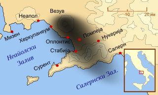
Македонски: Карта на населените места погодени во избувот на Везув во 79 г.
English: A map in MacedonianSshowing the cities and towns affected by the eruption of Mount Vesuvius in 79 AD |
| Date | |
| Source | File:Mt Vesuvius 79 AD eruption.svg |
| Author |
original by MapMaster derivative by B. Jankuloski |
| Other versions |
[]
|


Licensing[edit]
This file is licensed under the Creative Commons Attribution-Share Alike 4.0 International license.
- You are free:
- to share – to copy, distribute and transmit the work
- to remix – to adapt the work
- Under the following conditions:
- attribution – You must give appropriate credit, provide a link to the license, and indicate if changes were made. You may do so in any reasonable manner, but not in any way that suggests the licensor endorses you or your use.
- share alike – If you remix, transform, or build upon the material, you must distribute your contributions under the same or compatible license as the original.
File history
Click on a date/time to view the file as it appeared at that time.
| Date/Time | Thumbnail | Dimensions | User | Comment | |
|---|---|---|---|---|---|
| current | 05:19, 15 September 2021 | | 800 × 482 (143 KB) | Bjankuloski06 (talk | contribs) | Uploaded a work by original by MapMaster<br>derivative by B. Jankuloski from File:Mt Vesuvius 79 AD eruption.svg with UploadWizard |
You cannot overwrite this file.
File usage on Commons
The following 11 pages use this file:
- User:Magog the Ogre/Multilingual legend/2021 September 11-20
- File:Mt Vesuvius 79 AD eruption-fr.svg
- File:Mt Vesuvius 79 AD eruption-he.svg
- File:Mt Vesuvius 79 AD eruption-la.svg
- File:Mt Vesuvius 79 AD eruption-mk.svg
- File:Mt Vesuvius 79 AD eruption-nl.svg
- File:Mt Vesuvius 79 AD eruption-ru.svg
- File:Mt Vesuvius 79 AD eruption.svg
- File:Mt Vesuvius 79 AD eruption ZH.svg
- File:Vesuvius 79 AD eruption Latina-pt.svg
- Template:Other versions/Mt Vesuvius 79 AD eruption
File usage on other wikis
The following other wikis use this file:
- Usage on mk.wikipedia.org