File:MourningDoveRange.png
Jump to navigation
Jump to search
No higher resolution available.
MourningDoveRange.png (377 × 295 pixels, file size: 7 KB, MIME type: image/png)
Captions
Captions
Add a one-line explanation of what this file represents

|
This biogeographical map image could be re-created using vector graphics as an SVG file. This has several advantages; see Commons:Media for cleanup for more information. If an SVG form of this image is available, please upload it and afterwards replace this template with
{{vector version available|new image name}}.
It is recommended to name the SVG file “MourningDoveRange.svg”—then the template Vector version available (or Vva) does not need the new image name parameter. |
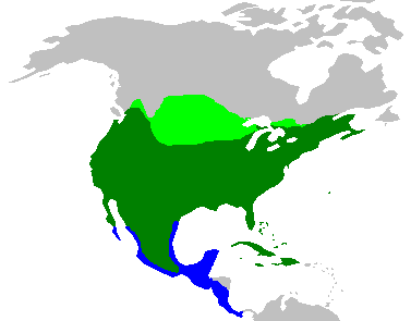
| Description | The range of the w:Mourning Dove | ||
| Source | Based on W:Image:BlankMap-World-noborders.png, created by W:User:E Pluribus Anthony on the Wikipedia. The information is based on information in [1], which is a work of the US Federal Government. | ||
| Author | Me and Wikipedia's E Pluribus Anthony | ||
| Permission (Reusing this file) |
|
File history
Click on a date/time to view the file as it appeared at that time.
| Date/Time | Thumbnail | Dimensions | User | Comment | |
|---|---|---|---|---|---|
| current | 23:13, 24 November 2006 | | 377 × 295 (7 KB) | Miss Madeline~commonswiki (talk | contribs) | {{Information |Description=The range of the w:Mourning Dove |Source=Based on W:Image:BlankMap-World-noborders.png, created by W:User:E Pluribus Anthony on the Wikipedia. The information is based on information in [http://www.sc.nrcs.usda.gov/i |
You cannot overwrite this file.
File usage on Commons
The following 2 pages use this file:
File usage on other wikis
The following other wikis use this file:
- Usage on ar.wikipedia.org
- Usage on arz.wikipedia.org
- Usage on ast.wikipedia.org
- Usage on bg.wikipedia.org
- Usage on ca.wikipedia.org
- Usage on ceb.wikipedia.org
- Usage on cs.wikipedia.org
- Usage on cy.wikipedia.org
- Usage on de.wikipedia.org
- Usage on eo.wikipedia.org
- Usage on es.wikipedia.org
- Usage on eu.wikipedia.org
- Usage on fa.wikipedia.org
- Usage on fr.wikipedia.org
- Usage on ga.wikipedia.org
- Usage on hr.wikipedia.org
- Usage on hu.wikipedia.org
- Usage on it.wikipedia.org
- Usage on nl.wikipedia.org
- Usage on nv.wikipedia.org
- Usage on pt.wikipedia.org
- Usage on ru.wikipedia.org
- Usage on simple.wikipedia.org
- Usage on species.wikimedia.org
- Usage on sv.wikipedia.org
- Usage on ta.wikipedia.org
- Usage on th.wikipedia.org
- Usage on uk.wikipedia.org
- Usage on vi.wikipedia.org
- Usage on www.wikidata.org
- Usage on zh.wikipedia.org