File:Mountainous Armenia 1921.png
Jump to navigation
Jump to search
Size of this preview: 656 × 599 pixels. Other resolutions: 263 × 240 pixels | 526 × 480 pixels | 934 × 853 pixels.
Original file (934 × 853 pixels, file size: 47 KB, MIME type: image/png)
Captions
Captions
Add a one-line explanation of what this file represents
Summary[edit]
| Description |
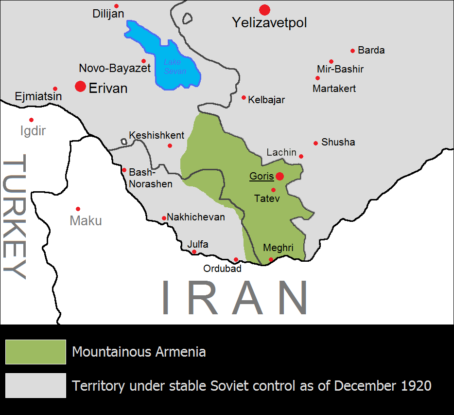
English: The Republic of Mountainous Armenia from December 1920 to June 1921. Unknown լեռնահայաստանը՝ 1921 թվականին: |
| Date | |
| Source | Own work |
| Author | Yerevanci |
Licensing[edit]
I, the copyright holder of this work, hereby publish it under the following license:
This file is licensed under the Creative Commons Attribution-Share Alike 3.0 Unported license.
- You are free:
- to share – to copy, distribute and transmit the work
- to remix – to adapt the work
- Under the following conditions:
- attribution – You must give appropriate credit, provide a link to the license, and indicate if changes were made. You may do so in any reasonable manner, but not in any way that suggests the licensor endorses you or your use.
- share alike – If you remix, transform, or build upon the material, you must distribute your contributions under the same or compatible license as the original.

|
This historical map image could be re-created using vector graphics as an SVG file. This has several advantages; see Commons:Media for cleanup for more information. If an SVG form of this image is available, please upload it and afterwards replace this template with
{{vector version available|new image name}}.
It is recommended to name the SVG file “Mountainous Armenia 1921.svg”—then the template Vector version available (or Vva) does not need the new image name parameter. |
File history
Click on a date/time to view the file as it appeared at that time.
| Date/Time | Thumbnail | Dimensions | User | Comment | |
|---|---|---|---|---|---|
| current | 11:56, 18 August 2023 | | 934 × 853 (47 KB) | Golden (talk | contribs) | Reverted to version as of 21:15, 17 July 2023 (UTC) It did not match the borders of East Zangezur either. Lachin city was under the control of Azeri-soviet forces by the time of this map. This file has no source anyway, it should not be used in Wikipedia articles |
| 18:11, 16 August 2023 |  | 934 × 853 (53 KB) | Kevo327 (talk | contribs) | Reverted to version as of 19:44, 17 July 2023 (UTC) I highly doubt the borders matched perfectly to the ones the Soviets drew | |
| 21:15, 17 July 2023 |  | 934 × 853 (47 KB) | Golden (talk | contribs) | Reverted to version as of 17:33, 17 July 2023 (UTC) The map itself has no source. Mountainous Armenia almost never controlled East Zangezur and was under Soviet control during this time (not Azeri, sorry for the confusion) | |
| 19:44, 17 July 2023 |  | 934 × 853 (53 KB) | Rototekaraka (talk | contribs) | Reverted to version as of 17:55, 15 July 2023 (UTC) No source was provided to the edit made by the user Golden in regards to "east Zangezur (modern Azerbaijan) was under Azeri control at this time". The Azerbaijan Democratic Republic had ceased to exist in april of 1920, nearly 8 months before the Mountainous Republic of Armenia was established making it impossible for the lands highlighted by the edit to be "under Azeri control at this time". | |
| 17:33, 17 July 2023 |  | 934 × 853 (47 KB) | Golden (talk | contribs) | Reverted to version as of 08:47, 17 July 2023 (UTC) vandalism | |
| 10:17, 17 July 2023 |  | 934 × 853 (53 KB) | Rototekaraka (talk | contribs) | Reverted to version as of 17:55, 15 July 2023 (UTC) | |
| 08:47, 17 July 2023 |  | 934 × 853 (47 KB) | Golden (talk | contribs) | Reverted to version as of 14:39, 1 November 2022 (UTC) rv vandalism | |
| 17:55, 15 July 2023 |  | 934 × 853 (53 KB) | Rototekaraka (talk | contribs) | Reverted to version as of 03:51, 3 February 2015 (UTC) | |
| 14:39, 1 November 2022 |  | 934 × 853 (47 KB) | Golden (talk | contribs) | east Zangezur (modern Azerbaijan) was under Azeri control at this time | |
| 03:51, 3 February 2015 |  | 934 × 853 (53 KB) | Yerevantsi (talk | contribs) | tweak |
You cannot overwrite this file.
File usage on Commons
There are no pages that use this file.
File usage on other wikis
The following other wikis use this file:
- Usage on az.wikipedia.org
- Usage on be-tarask.wikipedia.org
- Usage on de.wikipedia.org
- Usage on en.wikipedia.org
- Usage on eo.wikipedia.org
- Usage on eo.wikinews.org
- Usage on es.wikipedia.org
- Usage on fi.wikipedia.org
- Usage on fr.wikipedia.org
- Usage on id.wikipedia.org
- Usage on ja.wikipedia.org
- Usage on ka.wikipedia.org
- Usage on ko.wikipedia.org
- Usage on mt.wikipedia.org
- Usage on nl.wikipedia.org
- Usage on pl.wikipedia.org
- Usage on pt.wikipedia.org
- Usage on ru.wikipedia.org
- Usage on tr.wikipedia.org
- Usage on uk.wikipedia.org
- Usage on vi.wikipedia.org
- Usage on www.wikidata.org
- Usage on zh.wikipedia.org