File:Mountain lake, Mylgval mountain cirque, Western Caucasus.jpg
Jump to navigation
Jump to search

Size of this preview: 800 × 532 pixels. Other resolutions: 320 × 213 pixels | 640 × 425 pixels | 1,024 × 680 pixels | 1,280 × 851 pixels | 2,560 × 1,701 pixels | 4,912 × 3,264 pixels.
Original file (4,912 × 3,264 pixels, file size: 15.1 MB, MIME type: image/jpeg)
Captions
Captions
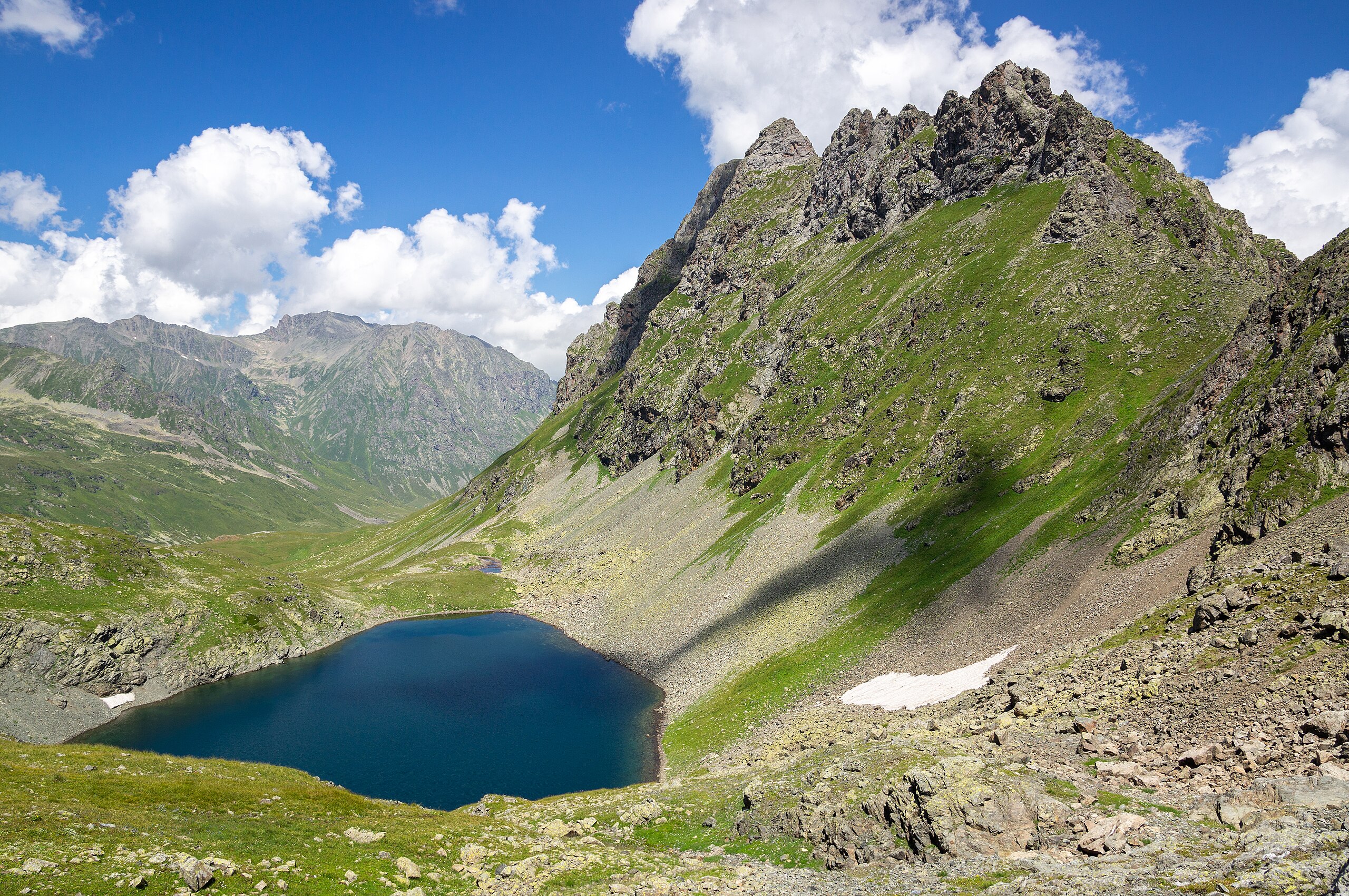
Mountain cirque with lake and rock formation. Caucasus Mountains.
Summary[edit]
| Description |
English: Rare, small-scale (about 600 metres (2,000 ft) in diameter), ancient glacial erosion cirque with high-altitude lake (2,730 metres (8,960 ft) a. s. l.) and rock formation (300 metres (980 ft) prominence) on one side. Abishira-Akhuba Ridge, Karachay-Cherkessia, Western Caucasus, Russia.
Русский: Озеро Мылгвал (Подскальное). Горные озерные цирки хребта Абишира-Ахуба. Дивная первозданная красота: острые скалистые вершины, цирки, кары, карсты, узкие глубокие ущелья, расчлененные плато. Кавказские горы. Карачаево-Черкесия, Западный Кавказ, Россия. |
| Date | |
| Source | Own work |
| Author | Vyacheslav Argenberg |
| Camera location | | View this and other nearby images on: OpenStreetMap |
|---|

|
This image was taken by Vyacheslav Argenberg
If you have any questions, comments or queries, please contact me. |

|
Assessment[edit]
|
Licensing[edit]
Vyacheslav Argenberg, the copyright holder of this work, hereby publishes it under the following license:
This file is licensed under the Creative Commons Attribution 4.0 International license.
Attribution: © Vyacheslav Argenberg / http://www.vascoplanet.com/
- You are free:
- to share – to copy, distribute and transmit the work
- to remix – to adapt the work
- Under the following conditions:
- attribution – You must give appropriate credit, provide a link to the license, and indicate if changes were made. You may do so in any reasonable manner, but not in any way that suggests the licensor endorses you or your use.
File history
Click on a date/time to view the file as it appeared at that time.
| Date/Time | Thumbnail | Dimensions | User | Comment | |
|---|---|---|---|---|---|
| current | 20:05, 27 April 2024 | | 4,912 × 3,264 (15.1 MB) | Argenberg (talk | contribs) | Reprocessed for higher fidelity. |
| 19:06, 30 January 2021 |  | 4,912 × 3,264 (12.02 MB) | Argenberg (talk | contribs) | Uploaded own work with UploadWizard |
You cannot overwrite this file.
File usage on Commons
The following 9 pages use this file:
- User talk:Argenberg
- Commons:Featured picture candidates/File:Mountain lake, Mylgval mountain cirque, Western Caucasus.jpg
- Commons:Featured picture candidates/Log/May 2024
- Commons:Featured pictures/Places/Natural/Russia
- Commons:Featured pictures/chronological/May 2024
- Commons:Featured pictures/hu
- Commons:Quality images/Subject/Places/Natural structures/archive 2021
- Commons:Quality images candidates/Archives March 07 2021
- File:Карачаево-Черкесия, Кавказ, Абишира-Ахуба, Озеро Мылгвал у перевала Мылгвал.jpg (file redirect)
File usage on other wikis
The following other wikis use this file:
- Usage on el.wikipedia.org