File:Mount Triglav, Slovenia (32438383878).jpg
Original file (5,011 × 3,666 pixels, file size: 5.16 MB, MIME type: image/jpeg)
Captions
Captions
Summary[edit]
.jpg&action=edit§ion=1)
| Description |
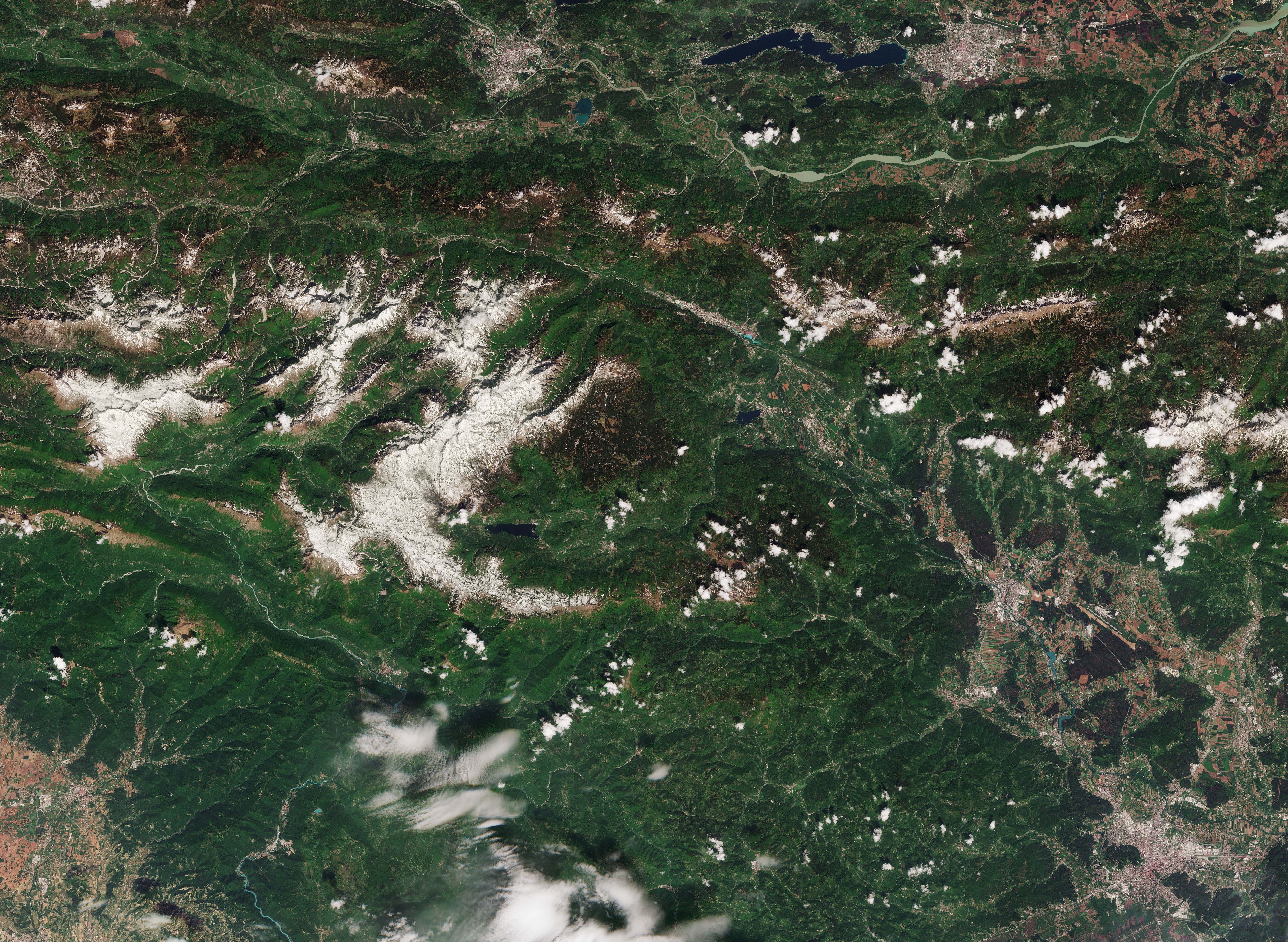
English: The Copernicus Sentinel-2A satellite takes us over Mount Triglav in Slovenia. At 2800 m above sea level, the mountain is the highest in the country and a significant source of national pride, even featuring on the Slovenian coat of arms. Milan Kucan, the former president, famously once said that it was the duty of every countryman and woman to scale the mountain at least once in their lives. The snow-peaked mountain is visible in the centre of the image, flanked by the popular tourist resort of Bled to the west. This small town is a popular base for skiers in the winter and for water-sport enthusiasts in the summer who make the most of the alpine lake of the same name. In the lower-right part of this true-colour image, we see the capital of Slovenia, Ljubljana, home to just under 300 000 people and the cultural, administrative and economic centre of the country. Famous for its environmental credentials, the city was named European Green Capital in 2016. This is thanks to shifting the focus from car transport to public transport, by pedestrianising areas of the city and by taking concerted efforts to preserve and protect green areas. Slovenia is bordered by Austria, Italy, Croatia and Hungary. On the top-right of the image we can see Klagenfurt, the capital city of the southern Austrian province of Carinthia, located by Lake Wörthersee. Sometimes referred to as the Caribbean of the Alps, the Lake area is where the famous Austrian composer, Gustav Mahler, wrote some of his best-known symphonies. Sentinel-2 data can be used to monitor agriculture, biodiversity, and coastal and inland waters, helping to supply the coverage and data delivery needed for Europe’s Copernicus environmental monitoring programme. |
| Date | |
| Source | Mount Triglav, Slovenia / http://www.esa.int/spaceinimages/Images/2018/12/Mount_Triglav_Slovenia |
| Author | European Space Agency |
| Camera location | | View this and other nearby images on: OpenStreetMap |
|---|
.jpg¶ms=046.362418_N_0013.839640_E_globe:Earth_type:camera_source:Flickr_&language=en)
Licensing[edit]
.jpg&action=edit§ion=2)
- You are free:
- to share – to copy, distribute and transmit the work
- to remix – to adapt the work
- Under the following conditions:
- attribution – You must give appropriate credit, provide a link to the license, and indicate if changes were made. You may do so in any reasonable manner, but not in any way that suggests the licensor endorses you or your use.
- share alike – If you remix, transform, or build upon the material, you must distribute your contributions under the same or compatible license as the original.

|
This image contains data from a satellite in the Copernicus Programme, such as Sentinel-1, Sentinel-2 or Sentinel-3. Attribution is required when using this image.
Attribution: Contains modified Copernicus Sentinel data {{{year}}}
The use of Copernicus Sentinel Data is regulated under EU law (Commission Delegated Regulation (EU) No 1159/2013 and Regulation (EU) No 377/2014). Relevant excerpts:
Free access shall be given to GMES dedicated data [...] made available through GMES dissemination platforms [...].
Access to GMES dedicated data [...] shall be given for the purpose of the following use in so far as it is lawful:
GMES dedicated data [...] may be used worldwide without limitations in time.
GMES dedicated data and GMES service information are provided to users without any express or implied warranty, including as regards quality and suitability for any purpose. |
- You are free:
- to share – to copy, distribute and transmit the work
- to remix – to adapt the work
- Under the following conditions:
- attribution – You must give appropriate credit, provide a link to the license, and indicate if changes were made. You may do so in any reasonable manner, but not in any way that suggests the licensor endorses you or your use.
- share alike – If you remix, transform, or build upon the material, you must distribute your contributions under the same or compatible license as the original.
| This image was originally posted to Flickr by europeanspaceagency at https://flickr.com/photos/37472264@N04/32438383878 (archive). It was reviewed on 14 December 2018 by FlickreviewR 2 and was confirmed to be licensed under the terms of the cc-by-sa-2.0. |
File history
Click on a date/time to view the file as it appeared at that time.
| Date/Time | Thumbnail | Dimensions | User | Comment | |
|---|---|---|---|---|---|
| current | 21:02, 14 December 2018 | | 5,011 × 3,666 (5.16 MB) | Sporti (talk | contribs) | Transferred from Flickr via #flickr2commons |
You cannot overwrite this file.
File usage on Commons
The following 3 pages use this file:
File usage on other wikis
The following other wikis use this file:
- Usage on sl.wikipedia.org
.jpg&oldid=649598529)