File:Mount Everest - Himalayas.jpg

Original file (3,508 × 2,553 pixels, file size: 2.09 MB, MIME type: image/jpeg)
Captions
Captions
Summary[edit]
| Description |
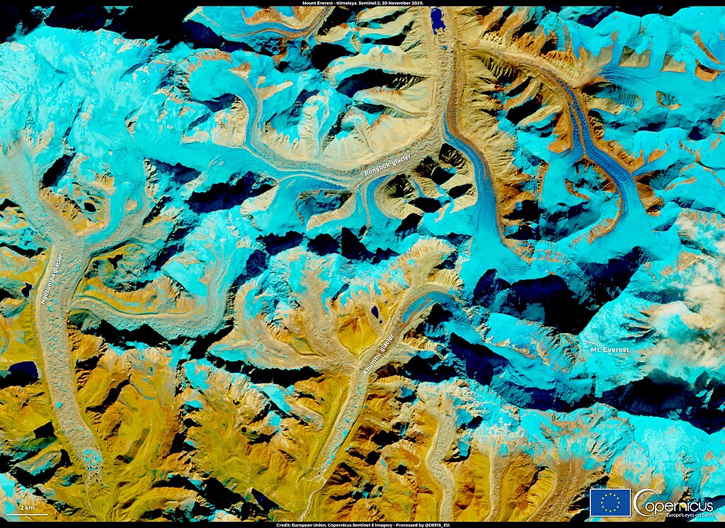
English: This image, acquired by one of the Copernicus Sentinel-2 satellites on 18 November, shows Mt. Everest in the Mahalangur Himal sub-range of the Himalayas Mountains. Mount Everest, with its 8848 meters above sea level (m.a.s.l), is the highest mountain on the Earth. It has always been tought of as a remote and pristine site, but according to a new study from researchers at the University of Plymouth, microplastics were found in Everest’ snow and stream water samples, up to 8,440 m.a.s.l. Researchers explain that the major source of pollution are polyester, acrylic, nylon, and polypropylene (i.e. materials used by the climbers during the climbing) and suggest to focus on the development of new environmental solutions to avoid further development of this source of pollution which is so significant, that it has earned Mt. Everest the title of “the world's highest junkyard”. Snow cover and glaciers are an important driver of many ecological, climatic and hydrological processes in the Himalayas Region: both snow and glaciers can be monitored and mapped using the Copernicus Sentinel-2 satellites. |
| Date | Taken on 18 November 2020 |
| Source | Mount Everest - Himalayas |
| Author | European Union , Copernicus Sentinel-2 imagery |
Licensing[edit]

|
This image contains data from a satellite in the Copernicus Programme, such as Sentinel-1, Sentinel-2 or Sentinel-3. Attribution is required when using this image.
Attribution: Contains modified Copernicus Sentinel data 2020
The use of Copernicus Sentinel Data is regulated under EU law (Commission Delegated Regulation (EU) No 1159/2013 and Regulation (EU) No 377/2014). Relevant excerpts:
Free access shall be given to GMES dedicated data [...] made available through GMES dissemination platforms [...].
Access to GMES dedicated data [...] shall be given for the purpose of the following use in so far as it is lawful:
GMES dedicated data [...] may be used worldwide without limitations in time.
GMES dedicated data and GMES service information are provided to users without any express or implied warranty, including as regards quality and suitability for any purpose. |
File history
Click on a date/time to view the file as it appeared at that time.
| Date/Time | Thumbnail | Dimensions | User | Comment | |
|---|---|---|---|---|---|
| current | 09:44, 24 August 2023 | | 3,508 × 2,553 (2.09 MB) | OptimusPrimeBot (talk | contribs) | #Spacemedia - Upload of https://www.copernicus.eu/system/files/2020-11/image_day/MtEverest_credit_row_logo.jpg via Commons:Spacemedia |
You cannot overwrite this file.
File usage on Commons
There are no pages that use this file.