File:MoonTopoGeoidUSGS-fr.jpg
Jump to navigation
Jump to search
No higher resolution available.
MoonTopoGeoidUSGS-fr.jpg (800 × 595 pixels, file size: 299 KB, MIME type: image/jpeg)
Captions
Captions
Add a one-line explanation of what this file represents
| Description |
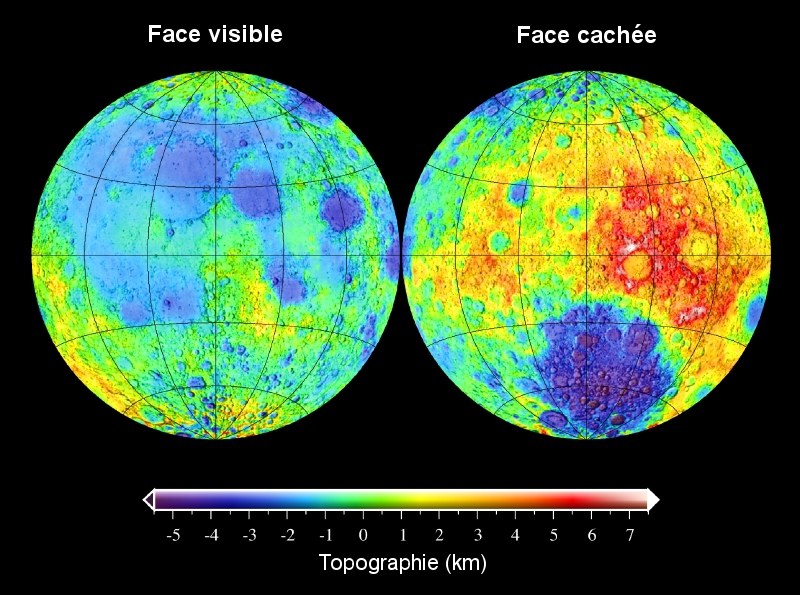
The topography of the Moon referenced to the lunar geoid. The topogographic model is derived from the spherical harmonic model USGS359, and the lunar geoid was obtained from the gravity model LP150Q. The color coded topography is overlain on a shaded relief map. Textes de l'image en français. |
| Date | (UTC) |
| Source | |
| Author |
|
| Other versions |
[]
|


| This is a retouched picture, which means that it has been digitally altered from its original version. The original can be viewed here: MoonTopoGeoidUSGS.jpg:
|
I, the copyright holder of this work, hereby publish it under the following licenses:
This file is licensed under the Creative Commons Attribution 2.5 Generic license.
- You are free:
- to share – to copy, distribute and transmit the work
- to remix – to adapt the work
- Under the following conditions:
- attribution – You must give appropriate credit, provide a link to the license, and indicate if changes were made. You may do so in any reasonable manner, but not in any way that suggests the licensor endorses you or your use.
| This file is licensed under the Creative Commons Attribution-Share Alike 3.0 Unported license. | ||
| ||
| This licensing tag was added to this file as part of the GFDL licensing update. |

|
Permission is granted to copy, distribute and/or modify this document under the terms of the GNU Free Documentation License, Version 1.2 or any later version published by the Free Software Foundation; with no Invariant Sections, no Front-Cover Texts, and no Back-Cover Texts. A copy of the license is included in the section entitled GNU Free Documentation License. |
You may select the license of your choice.
Original upload log[edit]
This image is a derivative work of the following images:
- File:MoonTopoGeoidUSGS.jpg licensed with Cc-by-2.5, Cc-by-sa-3.0-migrated, GFDL
- 2006-11-18T17:05:07Z Lunokhod 800x595 (354288 Bytes) {{Information| |Description = The topography of the Moon referenced to the lunar geoid. The topogographic model is derived from the spherical harmonic model [http://www.ipgp.jussieu.fr/~wieczor/SH/SH.html USGS359], and the lu
Uploaded with derivativeFX
File history
Click on a date/time to view the file as it appeared at that time.
| Date/Time | Thumbnail | Dimensions | User | Comment | |
|---|---|---|---|---|---|
| current | 12:01, 5 April 2011 | | 800 × 595 (299 KB) | Fylip22 (talk | contribs) | {{Information |Description=The topography of the Moon referenced to the lunar geoid. The topogographic model is derived from the spherical harmonic model [http://www.ipgp.jussieu.fr/~wieczor/SH/SH.html USGS359], and the lunar geoid was obtained from the g |
You cannot overwrite this file.
File usage on Commons
The following 8 pages use this file:
File usage on other wikis
The following other wikis use this file:
- Usage on fi.wikipedia.org
- Usage on fr.wikipedia.org
- Usage on it.wikipedia.org
- Usage on oc.wikipedia.org
- Usage on ro.wikipedia.org