File:Montpellier plantation home.jpg
Jump to navigation
Jump to search

Size of this preview: 790 × 599 pixels. Other resolutions: 317 × 240 pixels | 633 × 480 pixels | 1,012 × 768 pixels | 1,280 × 971 pixels | 2,560 × 1,942 pixels | 3,986 × 3,024 pixels.
Original file (3,986 × 3,024 pixels, file size: 7.05 MB, MIME type: image/jpeg)
Captions
Captions
Add a one-line explanation of what this file represents
Summary[edit]
| Description |
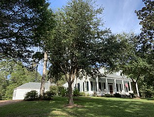
English: Montpellier is a southern colonial antebellum home which was built in the 1850s by Charles Whitmore.Present day Montpellier is owned by business owner Kelly Shutt and his wife Elizabeth Shutt.Montpellier is located on Liberty road to the north side. Montpellier features Greek revival architectural Style throughout the house.The house still features two original fire places in the front of the house as well as the original baluster going up to the second floor. Montpellier has been on the National Register of Historic Places since December 18, 1979.
|
||
| Date | |||
| Source | Own work | ||
| Author | Jacobpshutt |
| Camera location | | View this and other nearby images on: OpenStreetMap |
|---|
Licensing[edit]
I, the copyright holder of this work, hereby publish it under the following license:
This file is licensed under the Creative Commons Attribution-Share Alike 4.0 International license.
- You are free:
- to share – to copy, distribute and transmit the work
- to remix – to adapt the work
- Under the following conditions:
- attribution – You must give appropriate credit, provide a link to the license, and indicate if changes were made. You may do so in any reasonable manner, but not in any way that suggests the licensor endorses you or your use.
- share alike – If you remix, transform, or build upon the material, you must distribute your contributions under the same or compatible license as the original.
File history
Click on a date/time to view the file as it appeared at that time.
| Date/Time | Thumbnail | Dimensions | User | Comment | |
|---|---|---|---|---|---|
| current | 17:08, 17 February 2020 | | 3,986 × 3,024 (7.05 MB) | Jacobpshutt (talk | contribs) | User created page with UploadWizard |
You cannot overwrite this file.
File usage on Commons
There are no pages that use this file.
File usage on other wikis
The following other wikis use this file:
- Usage on en.wikipedia.org