File:Mojave Desert, Tehachapi Mountains, and San Joaquin Valley (California) – satellite image.jpg
Jump to navigation
Jump to search

Size of this preview: 800 × 484 pixels. Other resolutions: 320 × 194 pixels | 640 × 387 pixels | 1,024 × 619 pixels | 1,280 × 774 pixels | 2,560 × 1,548 pixels | 8,824 × 5,336 pixels.
Original file (8,824 × 5,336 pixels, file size: 13.03 MB, MIME type: image/jpeg)
Captions
Captions
Add a one-line explanation of what this file represents
Summary[edit]
| Description |
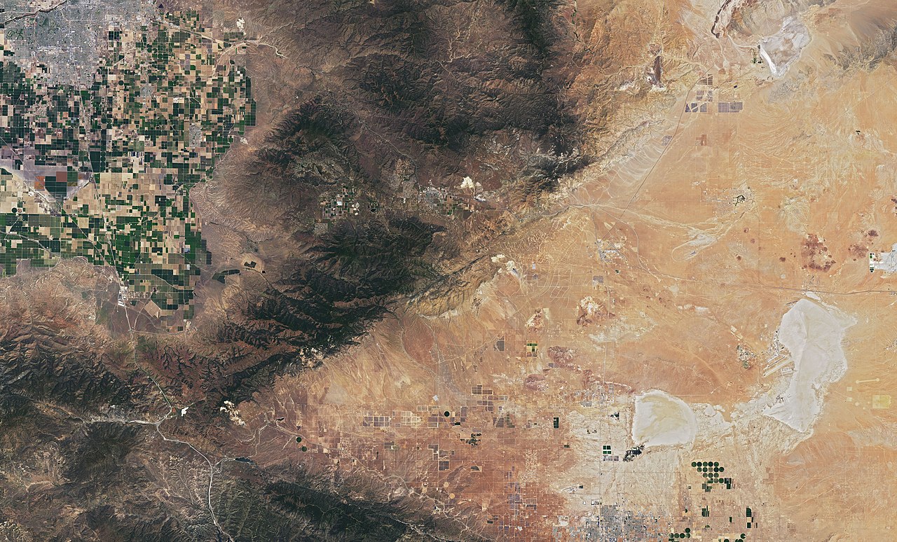
English: Satellite image of Mojave Desert (right), Tehachapi Mountains (Transverse Ranges) (center) and the southermost part of San Joaquin Valley (top left) in California. Mostly Kern County, the southermost part Los Angeles County.
On July 1, 2019, Operational Land Imager (OLI) on NASA's Landsat 8 acquired this image. Well visible landmarks: Bakersfield and the farmlands of San Joaquin Valley (top left). Tehachapi Pass (center). To the right of it, a massive amount of wind turbines (mostly Alta Wind Energy Center, one of the biggest wind farms in the world), which are connected by both straight and sinuous access roads. Rogers Dry Lake (bottom right) with Edwards Air Force Base, where the first Space Shuttle landed (then back-up landing site to Kennedy Space Center, Florida). |
| Date | |
| Source | https://earthobservatory.nasa.gov/images/145607/cameron-ridge?src=ve |
| Author | NASA |
_%E2%80%93_satellite_image.jpg)

,_California_%E2%80%93_satellite_image.jpg)


_%E2%80%93_satellite_image.jpg&action=edit§ion=1)
,_California_%E2%80%93_satellite_image.jpg)
_California_%E2%80%93_labeled_satellite_image.png)
Licensing[edit]
_%E2%80%93_satellite_image.jpg&action=edit§ion=2)
| This file is in the public domain in the United States because it was solely created by NASA. NASA copyright policy states that "NASA material is not protected by copyright unless noted". (See Template:PD-USGov, NASA copyright policy page or JPL Image Use Policy.) | ||
 |
Warnings:
|
File history
Click on a date/time to view the file as it appeared at that time.
| Date/Time | Thumbnail | Dimensions | User | Comment | |
|---|---|---|---|---|---|
| current | 21:08, 12 October 2019 | | 8,824 × 5,336 (13.03 MB) | A11w1ss3nd (talk | contribs) | {{Information |description ={{en|1=Satellite image of Mojave Desert (right), Tehachapi Mountains (Transverse Ranges) (center) and the southermost part of San Joaquin Valley (top left) in California. Mostly Kern County, the southermost part Los Angeles County. On July 1, 2019, Operational Land Imager (OLI) on NASA's Landsat 8 acquired this image. Well visible landmarks: Bakersfield and the farmlands of San Joaquin Valley (top left). Tehachapi Pass (center). To the right of it, a massive... |
You cannot overwrite this file.
File usage on Commons
The following 7 pages use this file:
- File:Central part of Tehachapi Wind Resource Area (Alta Wind Energy Center, Tehachapi Pass wind farm), California – satellite image.jpg
- File:Edwards Air Force Base, California – satellite image.jpg
- File:Hyundai Motor Group California Proving Ground from space.jpg
- File:Hyundai Motor Group California Proving Ground – satellite image.jpg
- File:Rogers Dry Lake (California) – satellite image.jpg
- File:Tehachapi Mountains (Transverse Ranges), California – satellite image.jpg
- File:Tehachapi Mountains (Transverse Ranges) California – labeled satellite image.png
_–_satellite_image.jpg&oldid=763587720)