File:Modrus Map-hr.png
Jump to navigation
Jump to search

Size of this preview: 415 × 599 pixels. Other resolutions: 166 × 240 pixels | 332 × 480 pixels | 687 × 992 pixels.
Original file (687 × 992 pixels, file size: 1.09 MB, MIME type: image/png)
Captions
Captions
Add a one-line explanation of what this file represents
Summary[edit]
| Description |
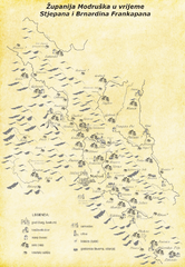
Hrvatski: Karta srednjovjekovne Modruške županije/župe u vrijeme Stjepana III i Bernardina Frankopana - 15. stoljeće (u slabijoj rezoluciji); ubikacija mjesta spomenutih u 'Modruškom urbaru' u mnogim je slučajevima dvojbena
English: Map of the medieval Frankopan estate, Modrus County in the time of Stjepan and Bernardin Frankopan - late 15th-Century (low resolution); ubication of some sattlements from 'Urbarium of Modruš 1486' is questionable in many cases |
| Date | |
| Source |
Own work ; |
| Author | Woluhar |
Licensing[edit]
I, the copyright holder of this work, hereby publish it under the following licenses:
This file is licensed under the Creative Commons Attribution-Share Alike 3.0 Unported license.
- You are free:
- to share – to copy, distribute and transmit the work
- to remix – to adapt the work
- Under the following conditions:
- attribution – You must give appropriate credit, provide a link to the license, and indicate if changes were made. You may do so in any reasonable manner, but not in any way that suggests the licensor endorses you or your use.
- share alike – If you remix, transform, or build upon the material, you must distribute your contributions under the same or compatible license as the original.

|
Permission is granted to copy, distribute and/or modify this document under the terms of the GNU Free Documentation License, Version 1.2 or any later version published by the Free Software Foundation; with no Invariant Sections, no Front-Cover Texts, and no Back-Cover Texts. A copy of the license is included in the section entitled GNU Free Documentation License. |
You may select the license of your choice.
File history
Click on a date/time to view the file as it appeared at that time.
| Date/Time | Thumbnail | Dimensions | User | Comment | |
|---|---|---|---|---|---|
| current | 12:57, 6 April 2013 | | 687 × 992 (1.09 MB) | Woluhar (talk | contribs) | {{Information |Description ={{hr|1=Karta srednjovjekovne Modruške županije/župe u vrijeme Stjepana III i Bernardina Frankopana - 15. stoljeće (u slabijoj rezoluciji); ubikacija mjesta spomenutih u 'Modruškom urbaru' u mnogim je slučajevima dvo... |
You cannot overwrite this file.
File usage on Commons
The following page uses this file: