File:Modern Jerusalem. 1864 Mitchell Map of Palestine, Israel or the Holy Land - Geographicus - Palestine-mitchell-1864.jpg

Original file (1,124 × 1,562 pixels, file size: 376 KB, MIME type: image/jpeg)
Captions
Captions
Summary[edit]
| Samuel Augustus Mitchell: Modern Jerusalem
( |
||||||||||||||||||||
|---|---|---|---|---|---|---|---|---|---|---|---|---|---|---|---|---|---|---|---|---|
| Artist |
|
|||||||||||||||||||
| Title |
Modern Jerusalem |
|||||||||||||||||||
| Description |
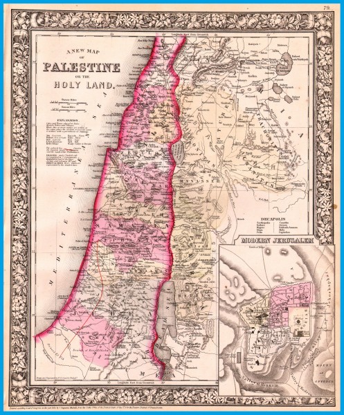
English: A New Map of Palestine or the Holy Land. A beautiful example of S. A. Mitchell Jr.’s 1864 map of Palestine, Israel or the Holy Land. Updated from the 1860 variant with new details, an inset of Jerusalem, and a new 1864 copyright. Includes both political and geographic features and references to both Biblical and modern locations. Includes a note on the ten cities that made up the Roman Decapolis, the ruling body of the region. One of the most attractive American atlas maps of this region to appear in the mid 19th century. Features the floral border typical of Mitchell maps from the 1860-65 period. Prepared by W. H. Gamble for inclusion in the 1864 issue of Mitchell’s New General Atlas . Dated and copyrighted, “Entered according to Act of Congress in the Year 1864 by S. Augustus Mitchell in the Clerk’s Office of the District Court of the U.S. for the Eastern District of Pennsylvania. |
|||||||||||||||||||
| Date | 1864 (dated) | |||||||||||||||||||
| Dimensions | height: 14.2 in (36.1 cm); width: 11.7 in (29.8 cm) | |||||||||||||||||||
| Accession number |
Geographicus link: Palestine-mitchell-1864 |
|||||||||||||||||||
| Source/Photographer |
Mitchell's New General Atlas, containing Maps of the Various Countries of the World, Plans of Cities, Etc., Embraced in Fifty-three Quarto Maps, forming a series of Eighty-Four Map and Plans, together with Valuable Statistical Tables. (1864 Edition)
|
|||||||||||||||||||
| Other versions | http://www.balloon-juice.com/2014/07/15/the-two-state-solution-is-a-dead-parrot > .jpg | |||||||||||||||||||

Licensing[edit]
|
This is a faithful photographic reproduction of a two-dimensional, public domain work of art. The work of art itself is in the public domain for the following reason:
The official position taken by the Wikimedia Foundation is that "faithful reproductions of two-dimensional public domain works of art are public domain".
This photographic reproduction is therefore also considered to be in the public domain in the United States. In other jurisdictions, re-use of this content may be restricted; see Reuse of PD-Art photographs for details. | ||||
File history
Click on a date/time to view the file as it appeared at that time.
| Date/Time | Thumbnail | Dimensions | User | Comment | |
|---|---|---|---|---|---|
| current | 00:28, 22 January 2015 | | 1,124 × 1,562 (376 KB) | Geagea (talk | contribs) | {{Artwork |artist={{creator:Samuel Augustus Mitchell}} |title= {{title|Modern Jerusalem}} |description= {{en|1=A New Map of Palestine or the Holy Land. A beautiful example of S. A. Mitchell Jr.’s 1864 map of Palestine, Israel or the Holy Land. Updat... |
You cannot overwrite this file.
File usage on Commons
The following page uses this file: