File:Mk Frankfurt S-Bahn Offenbach B.svg
Jump to navigation
Jump to search

Size of this PNG preview of this SVG file: 800 × 222 pixels. Other resolutions: 320 × 89 pixels | 640 × 178 pixels | 1,024 × 284 pixels | 1,280 × 355 pixels | 2,560 × 711 pixels | 944 × 262 pixels.
Original file (SVG file, nominally 944 × 262 pixels, file size: 91 KB)
Captions
Captions
Add a one-line explanation of what this file represents
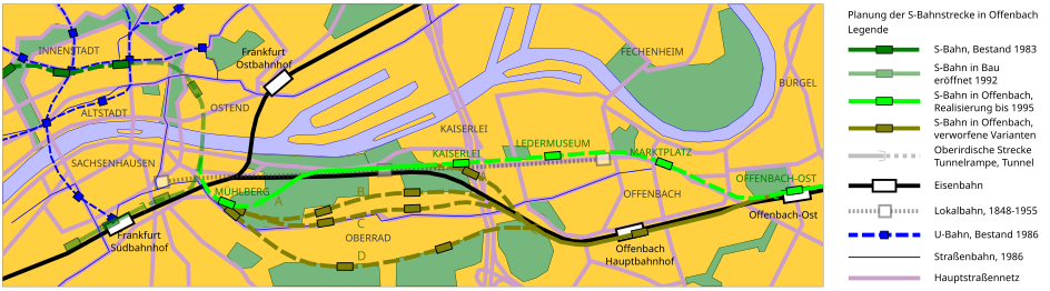
| Description | Karte mit abgeschliffenen Rändern. | ||||||||||
| Date | |||||||||||
| Source |
Image:Mk_Frankfurt_S-Bahn_Offenbach_A.svg Summary[edit]
Licensing[edit]I, the copyright holder of this work, hereby publish it under the following licenses:
This file is licensed under the Creative Commons Attribution-Share Alike 3.0 Unported, 2.5 Generic, 2.0 Generic and 1.0 Generic license.
You may select the license of your choice. |
||||||||||
| Author | de:Benutzer:Algos |

This W3C-unspecified vector image was created with Inkscape .
File history
Click on a date/time to view the file as it appeared at that time.
| Date/Time | Thumbnail | Dimensions | User | Comment | |
|---|---|---|---|---|---|
| current | 15:25, 18 August 2007 | 944 × 262 (91 KB) | Algos~commonswiki (talk | contribs) | {{Information |Description= Karte mit abgeschliffenen Rändern. |Source=Image:Mk_Frankfurt_S-Bahn_Offenbach_A.svg {{User:Magadan/Text | BESCHR_DE = Verworfene Planungsvarianten und Trassierung der letztlich (1990-95) realisierten Innenstadtstrecke de | |
| 15:31, 16 August 2007 | 944 × 262 (99 KB) | Algos~commonswiki (talk | contribs) | {{Information |Description= Karte mit abgeschliffenen Rändern. |Source=Image:Mk_Frankfurt_S-Bahn_Offenbach_A.svg {{User:Magadan/Text | BESCHR_DE = Verworfene Planungsvarianten und Trassierung der letztlich (1990-95) realisierten Innenstadtstrecke de | ||
| 14:58, 16 August 2007 | 944 × 262 (95 KB) | Algos~commonswiki (talk | contribs) | {{Information |Description= |Source=Image:Mk_Frankfurt_S-Bahn_Offenbach_A.svg {{User:Magadan/Text | BESCHR_DE = Verworfene Planungsvarianten und Trassierung der letztlich (1990-95) realisierten Innenstadtstrecke der [[S-Bahn Frankfurt|S-Bahn Rhein-Ma |
You cannot overwrite this file.
File usage on Commons
The following 2 pages use this file:
File usage on other wikis
The following other wikis use this file:
- Usage on de.wikipedia.org