File:Miyake-Jima, Japan (ASTER).jpg
Jump to navigation
Jump to search

Size of this preview: 799 × 259 pixels. Other resolutions: 320 × 104 pixels | 640 × 208 pixels | 1,866 × 605 pixels.
Original file (1,866 × 605 pixels, file size: 63 KB, MIME type: image/jpeg)
Captions
Captions
Add a one-line explanation of what this file represents
Summary[edit]
.jpg&action=edit§ion=1)
| Description |
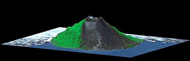
English: Mount Oyama is a 820-meter-high (2,700 feet) volcano on the island of Miyake-Jima, Japan, about 8 km (5 miles) in diameter. In late June 2000, a series of earthquakes alerted scientists to possible volcanic activity. On June 27, authorities evacuated 2,600 people, and on July 8 the volcano began erupting and erupted five times over that week. The dark gray blanket covering green vegetation in the image is the ash deposited by prevailing northeasterly winds between July 8 and 17. This island is about 180 kilometers (110 miles) south of Tokyo and is part of the Izu chain of volcanic islands that runs south from the main Japanese island of Honshu. Miyake-Jima is home to 3,800 people. The previous major eruptions of Mount Oyama occurred in 1983 and 1962, when lava flows destroyed hundreds of houses. An earlier eruption in 1940 killed 11 people. This image is a perspective view created by combining a July 17, 2000 image from ASTER with an elevation model from the Shuttle Radar Topography Mission (SRTM). Vertical relief is exaggerated, and the image includes cosmetic adjustments to clouds and image color to enhance clarity of terrain features. The image is centered at 34.1 degrees north latitude, 139.5 degrees east longitude. |
||
| Date | Taken on 17 July 2000 | ||
| Source |
Miyake-Jima, Japan (direct link)
|
||
| Author | NASA/METI/AIST/Japan Space Systems, and U.S./Japan ASTER Science Team |
| Camera location | | View this and other nearby images on: OpenStreetMap |
|---|
.jpg¶ms=034.100000_N_0139.500000_E_globe:Earth_type:camera__&language=en)
Licensing[edit]
.jpg&action=edit§ion=2)
| This file is in the public domain in the United States because it was solely created by NASA. NASA copyright policy states that "NASA material is not protected by copyright unless noted". (See Template:PD-USGov, NASA copyright policy page or JPL Image Use Policy.) | ||
 |
Warnings:
|
File history
Click on a date/time to view the file as it appeared at that time.
| Date/Time | Thumbnail | Dimensions | User | Comment | |
|---|---|---|---|---|---|
| current | 15:47, 30 April 2023 | 1,866 × 605 (63 KB) | OptimusPrimeBot (talk | contribs) | #Spacemedia - Upload of https://asterweb.jpl.nasa.gov/gallery/images/Miyake-vw.jpg via Commons:Spacemedia |
You cannot overwrite this file.
File usage on Commons
There are no pages that use this file.
.jpg&oldid=863530956)