File:Missouri area code map.gif
Jump to navigation
Jump to search

Size of this preview: 705 × 599 pixels. Other resolutions: 282 × 240 pixels | 565 × 480 pixels | 904 × 768 pixels | 1,205 × 1,024 pixels | 2,000 × 1,700 pixels.
Original file (2,000 × 1,700 pixels, file size: 568 KB, MIME type: image/gif)
Captions
Captions
Add a one-line explanation of what this file represents
Summary[edit]
| Description |
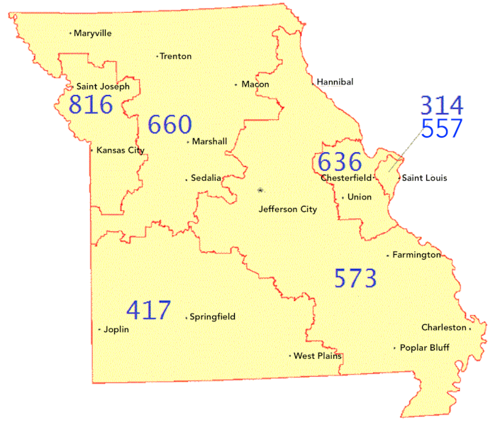
English: Missouri map with area codes and sections labeled. |
| Date | |
| Source | MS Paint |
| Author | Darkskynet |
Licensing[edit]
| This file is made available under the Creative Commons CC0 1.0 Universal Public Domain Dedication. | |
| The person who associated a work with this deed has dedicated the work to the public domain by waiving all of their rights to the work worldwide under copyright law, including all related and neighboring rights, to the extent allowed by law. You can copy, modify, distribute and perform the work, even for commercial purposes, all without asking permission.
|
File history
Click on a date/time to view the file as it appeared at that time.
| Date/Time | Thumbnail | Dimensions | User | Comment | |
|---|---|---|---|---|---|
| current | 01:12, 8 December 2022 | | 2,000 × 1,700 (568 KB) | Kbrose (talk | contribs) | resize image and replace city names with larger text |
| 17:22, 7 December 2022 |  | 550 × 467 (28 KB) | Kbrose (talk | contribs) | Add area code 557 | |
| 16:55, 3 December 2014 |  | 550 × 467 (27 KB) | Darkskynet (talk | contribs) | {{subst:Upload marker added by en.wp UW}} {{Information |Description = {{en|Missouri map with area codes and sections labeled.}} |Source = MS Paint |Date = 2014-12-03 |Author = Darkskynet }} {{cc-zero}} Category:Maps of Missouri |
You cannot overwrite this file.
File usage on Commons
The following page uses this file:
File usage on other wikis
The following other wikis use this file:
- Usage on en.wikipedia.org