File:Missaguash River.jpg
Jump to navigation
Jump to search

Size of this preview: 600 × 600 pixels. Other resolutions: 240 × 240 pixels | 480 × 480 pixels | 768 × 768 pixels | 1,024 × 1,024 pixels | 1,536 × 1,536 pixels.
Original file (1,536 × 1,536 pixels, file size: 579 KB, MIME type: image/jpeg)
Captions
Captions
Add a one-line explanation of what this file represents
Summary[edit]
| Description |
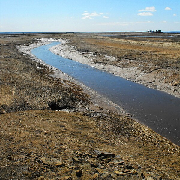
English: View looking downriver at the Missiguash during low tide. The river forms part of the boundary between New Brunswick and Nova Scotia, Canada. In the photo, Nova Scotia is on left side of the river and New Brunswick on the right. In the background is the National Historic Site of Tonges Island, former home of the Seigneur Michel de la Valliere who in 1676 had a manor house there. The island may be identified by the copse of trees. A modern home exists there now. |
| Date | |
| Source | Own work |
| Author | Verne Equinox |
This photo is of a cultural heritage site in Canada, number 14586
|
Licensing[edit]
I, the copyright holder of this work, hereby publish it under the following license:
This file is licensed under the Creative Commons Attribution 3.0 Unported license.
- You are free:
- to share – to copy, distribute and transmit the work
- to remix – to adapt the work
- Under the following conditions:
- attribution – You must give appropriate credit, provide a link to the license, and indicate if changes were made. You may do so in any reasonable manner, but not in any way that suggests the licensor endorses you or your use.
File history
Click on a date/time to view the file as it appeared at that time.
| Date/Time | Thumbnail | Dimensions | User | Comment | |
|---|---|---|---|---|---|
| current | 00:40, 19 April 2009 | | 1,536 × 1,536 (579 KB) | Verne Equinox (talk | contribs) | {{Information |Description={{en|1=View looking downriver of the Missiguash at low tide. the river forms part of the boundary between New Brunswick and Nova Scotia, Canada.}} |Source=Own work by uploader |Author=Verne Equinox |Date=2 |
You cannot overwrite this file.
File usage on Commons
The following 3 pages use this file:
File usage on other wikis
The following other wikis use this file:
- Usage on ceb.wikipedia.org
- Usage on de.wikipedia.org
- Usage on en.wikipedia.org
- Usage on es.wikipedia.org
- Usage on fr.wikipedia.org
- Usage on pl.wikipedia.org
- Usage on sv.wikipedia.org
- Usage on www.wikidata.org