File:Milpitas view2.JPG

Original file (2,104 × 1,580 pixels, file size: 872 KB, MIME type: image/jpeg)
Captions
Captions
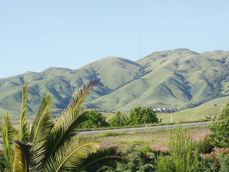
Looking east toward Monument Peak in Milpitas, California. The rightmost (tallest) antenna is Monument Peak, while the leftmost one (second highest, with three "forks" visible) is Mount Allison. The small antenna in the center was recently built. The gully to the far right of the mountainside is Calera Creek. Just to its left is Scott Creek. Most of the area can be accessed via hking trails in Ed R. Levin County Park.
Going right - south. Going left is north. Mount Allison is about a mile north of Monument Peak.
The actual point of Monument Peak is the point lying directly right (south) of the tallest antenna (FCC structure 1019291).
Notice Mount Allison's antenna - it has three "forks" on the top.
Can you see a few hiking trails leading up to Monument Peak?
The houses at the bottom of the mountains are the upper-class Calaveras Ridge Estates on Calaveras Ridge Road.
The hills are golden because of the dry summer season which dehydrates the grass on the hillsides. The hills are considered a high-risk fire hazard region.
| This work has been released into the public domain by its author, Milpitas guy at English Wikipedia. This applies worldwide. In some countries this may not be legally possible; if so: Milpitas guy grants anyone the right to use this work for any purpose, without any conditions, unless such conditions are required by law. |
.JPG)
File history
Click on a date/time to view the file as it appeared at that time.
| Date/Time | Thumbnail | Dimensions | User | Comment | |
|---|---|---|---|---|---|
| current | 15:33, 22 December 2006 | | 2,104 × 1,580 (872 KB) | Nk (talk | contribs) | Looking east toward Monument Peak in Milpitas, California. The rightmost (tallest) antenna is Monument Peak, while the leftmost one (second highest, with three "forks" visible) is Mount Allison. The small antenna in the center was recently built. The gull |
You cannot overwrite this file.
File usage on Commons
The following 3 pages use this file:
File usage on other wikis
The following other wikis use this file:
- Usage on arz.wikipedia.org
- Usage on ceb.wikipedia.org
- Usage on de.wikipedia.org
- Usage on en.wikipedia.org
- Usage on eo.wikipedia.org
- Usage on es.wikipedia.org
- Usage on fr.wikipedia.org
- Usage on he.wikipedia.org
- Usage on ja.wikipedia.org
- Usage on lld.wikipedia.org
- Usage on pam.wikipedia.org
- Usage on uz.wikipedia.org
- Usage on www.wikidata.org