File:Military Reservation of Fort Dodge.png
Jump to navigation
Jump to search

Size of this preview: 341 × 599 pixels. Other resolutions: 136 × 240 pixels | 273 × 480 pixels | 437 × 768 pixels | 583 × 1,024 pixels | 1,396 × 2,451 pixels.
Original file (1,396 × 2,451 pixels, file size: 3.36 MB, MIME type: image/png)
Captions
Captions
Add a one-line explanation of what this file represents
Summary[edit]
| Description |
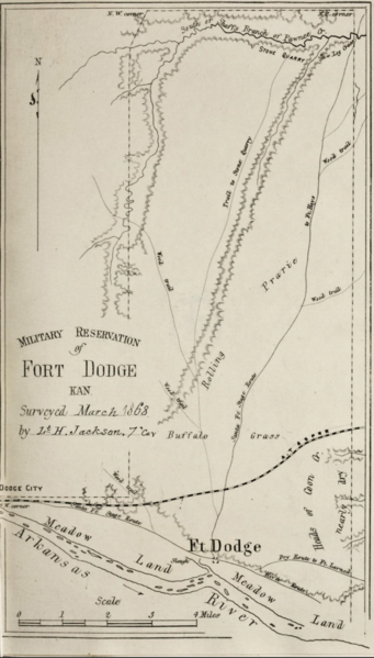
English: Map of the Military Reservation of Fort Dodge in Kansas. Established in 1864 and surveyed March 1868 |
| Date | |
| Source | Outline Descriptions of the Posts in the Military Division of the Missouri, commanded by Lieutenant General P. H. Sheridan. Chicago 1876. https://archive.org/details/GR_4327 |
| Author | Unknown author |
| Camera location | | View this and other nearby images on: OpenStreetMap |
|---|
North America, US, Kansas
Licensing[edit]
This work is in the public domain in the United States because it is a work prepared by an officer or employee of the United States Government as part of that person’s official duties under the terms of Title 17, Chapter 1, Section 105 of the US Code.
Note: This only applies to original works of the Federal Government and not to the work of any individual U.S. state, territory, commonwealth, county, municipality, or any other subdivision. This template also does not apply to postage stamp designs published by the United States Postal Service since 1978. (See § 313.6(C)(1) of Compendium of U.S. Copyright Office Practices). It also does not apply to certain US coins; see The US Mint Terms of Use.
|
 | |
| This file has been identified as being free of known restrictions under copyright law, including all related and neighboring rights. | ||
File history
Click on a date/time to view the file as it appeared at that time.
| Date/Time | Thumbnail | Dimensions | User | Comment | |
|---|---|---|---|---|---|
| current | 09:02, 30 June 2018 | | 1,396 × 2,451 (3.36 MB) | Naawada2016 (talk | contribs) | User created page with UploadWizard |
You cannot overwrite this file.
File usage on Commons
There are no pages that use this file.