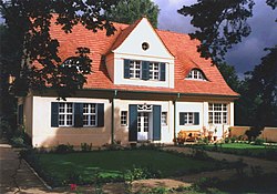
File:Mies van der Rohe - Haus Riehl (Südost) - Babelsberg.jpg
From Wikimedia Commons, the free media repository
Jump to navigation
Jump to search

Size of this preview: 800 × 533 pixels. Other resolutions: 320 × 213 pixels | 640 × 427 pixels | 1,024 × 683 pixels | 1,280 × 853 pixels | 2,560 × 1,707 pixels | 5,184 × 3,456 pixels.
Original file (5,184 × 3,456 pixels, file size: 14.46 MB, MIME type: image/jpeg)
File information
Structured data
Captions
Captions
Add a one-line explanation of what this file represents
Contents
Summary
Object
| Karl Foerster: Riehl House
|
||||||||||||||||||||||||||||||||||||||||||
|---|---|---|---|---|---|---|---|---|---|---|---|---|---|---|---|---|---|---|---|---|---|---|---|---|---|---|---|---|---|---|---|---|---|---|---|---|---|---|---|---|---|---|
| Artist |
|
|||||||||||||||||||||||||||||||||||||||||
| Architect |
|
|||||||||||||||||||||||||||||||||||||||||
| Title |
Riehl House label QS:Len,"Riehl House"
label QS:Lde,"Haus Riehl" |
|||||||||||||||||||||||||||||||||||||||||
| Object type |
single-family detached home |
|||||||||||||||||||||||||||||||||||||||||
| Description |
Deutsch: Erstlingswerk von Ludwig Mies van der Rohe, Westseite, nach Instandsetzung, Rekonstruktion und Innenausbau von Folkerts Architekten 1998 bis 2000.
|
|||||||||||||||||||||||||||||||||||||||||
| Date |
1907 |
|||||||||||||||||||||||||||||||||||||||||
| Medium |
plasterwork |
|||||||||||||||||||||||||||||||||||||||||
| Collection | ||||||||||||||||||||||||||||||||||||||||||
| Object location |
|
|||||||||||||||||||||||||||||||||||||||||
| Object history |
|
|||||||||||||||||||||||||||||||||||||||||
| References | ||||||||||||||||||||||||||||||||||||||||||
Photograph
| Date | |
| Source | Own work |
| Author | Charlotte Heineccius |
| Object location | 52° 24′ 20.31″ N, 13° 06′ 21.37″ E | View this and other nearby images on: OpenStreetMap |
|---|
Licensing
I, the copyright holder of this work, hereby publish it under the following license:
This file is licensed under the Creative Commons Attribution-Share Alike 3.0 Unported license.
- You are free:
- to share – to copy, distribute and transmit the work
- to remix – to adapt the work
- Under the following conditions:
- attribution – You must give appropriate credit, provide a link to the license, and indicate if changes were made. You may do so in any reasonable manner, but not in any way that suggests the licensor endorses you or your use.
- share alike – If you remix, transform, or build upon the material, you must distribute your contributions under the same or compatible license as the original.
File history
Click on a date/time to view the file as it appeared at that time.
| Date/Time | Thumbnail | Dimensions | User | Comment | |
|---|---|---|---|---|---|
| current | 05:00, 19 October 2023 |  | 5,184 × 3,456 (14.46 MB) | Charlotte Heineccius (talk | contribs) | =={{int:filedesc}}== {{Art photo |wikidata = Q99839577 |artist = |description = {{de|1=Erstlingswerk von Ludwig Mies van der Rohe, Westseite, nach Instandsetzung, Rekonstruktion und Innenausbau von Folkerts Architekten 1998 bis 2000. {{Baudenkmal Brandenburg|09156066}}}} |photo date = 2021 |source = {{own}} |photographer = Charlotte Heineccius |permission = |other_versions = }} {{Object location|52.405643|13.105935}} =={{int:license-header}}== {{self|c... |
You cannot overwrite this file.
File usage on Commons
The following page uses this file:
Metadata
This file contains additional information such as Exif metadata which may have been added by the digital camera, scanner, or software program used to create or digitize it. If the file has been modified from its original state, some details such as the timestamp may not fully reflect those of the original file. The timestamp is only as accurate as the clock in the camera, and it may be completely wrong.
| Camera manufacturer | Canon |
|---|---|
| Camera model | Canon EOS 1200D |
| Exposure time | 1/100 sec (0.01) |
| F-number | f/7.1 |
| ISO speed rating | 100 |
| Date and time of data generation | 15:34, 21 March 2021 |
| Lens focal length | 25 mm |
| Orientation | Normal |
| Horizontal resolution | 72 dpi |
| Vertical resolution | 72 dpi |
| File change date and time | 15:34, 21 March 2021 |
| Exposure Program | Not defined |
| Exif version | 2.3 |
| Date and time of digitizing | 15:34, 21 March 2021 |
| Meaning of each component |
|
| APEX shutter speed | 6.625 |
| APEX aperture | 5.625 |
| APEX exposure bias | 0 |
| Maximum land aperture | 3.8304131262819 APEX (f/3.77) |
| Metering mode | Pattern |
| Flash | Flash did not fire, compulsory flash suppression |
| DateTime subseconds | 95 |
| DateTimeOriginal subseconds | 95 |
| DateTimeDigitized subseconds | 95 |
| Supported Flashpix version | 1 |
| Color space | sRGB |
| Focal plane X resolution | 5,728.1767955801 |
| Focal plane Y resolution | 5,808.4033613445 |
| Focal plane resolution unit | inches |
| Custom image processing | Normal process |
| Exposure mode | Auto exposure |
| White balance | Auto white balance |
| Scene capture type | Standard |
| Lens used | Canon EF-S 18-135mm f/3.5-5.6 IS |
| Rating (out of 5) | 0 |
Structured data
Items portrayed in this file
depicts
52°24'20.315"N, 13°6'21.366"E
image/jpeg
8fb77341a8376f46f678bca18f7b64fb21a7a071
15,160,940 byte
3,456 pixel
5,184 pixel
Hidden categories:
- Pages with non-numeric formatnum arguments
- Cultural heritage monuments in Brandenburg with known ID
- Pages with complex technique templates
- Artworks with Wikidata item
- Artworks with Wikidata item missing genre
- Artworks main subject type unknown type of work
- Files with coordinates missing SDC location of creation
- CC-BY-SA-3.0
- Self-published work
- Pages with maps


