File:Messina-waves-image.jpg
Jump to navigation
Jump to search

Size of this preview: 387 × 600 pixels. Other resolutions: 155 × 240 pixels | 309 × 480 pixels | 495 × 768 pixels | 660 × 1,024 pixels | 1,321 × 2,048 pixels | 3,870 × 6,000 pixels.
Original file (3,870 × 6,000 pixels, file size: 4.28 MB, MIME type: image/jpeg)
Captions
Captions
Add a one-line explanation of what this file represents
| Description |
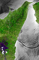
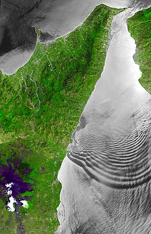
English: The Strait of Messina is a narrow channel separating the island of Sicily from the Italian peninsula, connecting the Ionian Sea with the Tyrrhenian Sea. In the Strait, strong tidal currents occur, which interact with the shallow sill located in its center. The mean depth of the Strait is only 80 m, compared to depths of over 800 m to the south. Internal wave trains of solitary waves can be generated, and these show up as sea surface manifestations because they are associated with variable surface currents that modify the surface roughness. ASTER sees these as dark (smooth) and light (rough) patterns when the solar illumination is at the correct angle relative to the orientation of the satellite. The ASTER images cover an area of 58 km x 90 km.
Deutsch: Die Straße von Messina ist eine Meerenge, die die Insel Sizilien von der italienischen Halbinsel trennt und das Ionische Meer mit dem Tyrrhenischen Meer verbindet. Hier treten starke Gezeitenströmungen auf, die mit der flachen Schwelle in ihrer Mitte interagieren. Die durchschnittliche Tiefe der Meerenge beträgt nur 80 m, im Vergleich zu Tiefen von über 800 m im Süden. Solitärwellen können Züge von internen Wellen erzeugen, und diese wirken auf die Meeresoberfläche, weil sie sich mit variablen Oberflächenströmungen überlagern und dabei die Oberflächenrauheit verändern. ASTER sieht diese Erscheinungen als dunkle (glatte) und helle (raue) Muster, wenn die Sonnenbeleuchtung im richtigen Winkel zur Ausrichtung des Satelliten steht. Die ASTER-Aufnahmen erstrecken sich über eine Fläche von 58 km x 90 km. |
| Date | |
| Source | http://asterweb.jpl.nasa.gov/gallery-detail.asp?name=messina-wave |
| Author |
NASA/GSFC/METI/ERSDAC/JAROS, and U.S./Japan ASTER Science Team |
| Object location | | View this and other nearby images on: OpenStreetMap |
|---|
Licensing[edit]
| This file is in the public domain in the United States because it was solely created by NASA. NASA copyright policy states that "NASA material is not protected by copyright unless noted". (See Template:PD-USGov, NASA copyright policy page or JPL Image Use Policy.) | ||
 |
Warnings:
|
Original upload log[edit]
The original description page was here. All following user names refer to de.wikipedia.
| Upload date | User | Bytes | Dimensions | Comment |
|---|---|---|---|---|
| 2009-06-02 22:17:24 | Herbertweidner | 4484167 | 3870×6000 | {{Information |Beschreibung = The Strait of Messina is a narrow channel separating the island of Sicily from the Italian peninsula, connecting the Ionian Sea with the Tyrrhenian Sea. In the Strait, strong tidal currents occur, which interact with the shal |
File history
Click on a date/time to view the file as it appeared at that time.
| Date/Time | Thumbnail | Dimensions | User | Comment | |
|---|---|---|---|---|---|
| current | 00:31, 29 March 2010 | | 3,870 × 6,000 (4.28 MB) | CommonsHelper2 Bot (talk | contribs) | {{BotMoveToCommons|de.wikipedia|year={{subst:CURRENTYEAR}}|month={{subst:CURRENTMONTHNAME}}|day={{subst:CURRENTDAY}}}} {{Information |Description = {{de |The Strait of Messina is a narrow channel separating the island of Sicily from the Italian peninsul |
You cannot overwrite this file.
File usage on Commons
The following page uses this file:
File usage on other wikis
The following other wikis use this file:
- Usage on da.wikipedia.org
- Usage on de.wikipedia.org
- Usage on en.wikipedia.org
- Usage on es.wikipedia.org
- Usage on it.wikipedia.org
- Usage on nl.wikipedia.org
- Usage on simple.wikipedia.org
- Usage on www.wikidata.org