File:Mesopotamia.PNG
Jump to navigation
Jump to search
No higher resolution available.
Mesopotamia.PNG (450 × 364 pixels, file size: 198 KB, MIME type: image/png)
Captions
Captions
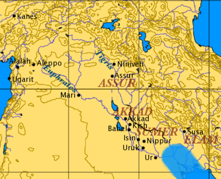
Overview map of ancient Mesopotamia
Summary[edit]
| Description |
|
||
| Source | Own work, via en.wikipedia.org | ||
| Author | User:Dbachmann |

Licensing[edit]
| |
This work has been released into the public domain by its author, Dbachmann, at the English Wikipedia project. This applies worldwide. In case this is not legally possible: |
| This image is from Planiglobe. All maps hosted on Planiglobe are licensed under the Creative Commons Attribution 2.5 License, but Planiglobe suggests that they not be used for navigational purposes. For the purposes of this license, this clause is considered a disclaimer and not a license restriction. This file is licensed under the Creative Commons Attribution 2.5 Generic license.
|
File history
Click on a date/time to view the file as it appeared at that time.
| Date/Time | Thumbnail | Dimensions | User | Comment | |
|---|---|---|---|---|---|
| current | 17:55, 1 January 2008 | | 450 × 364 (198 KB) | Mahahahaneapneap (talk | contribs) | pngcrushed |
| 17:03, 18 December 2006 |  | 450 × 364 (208 KB) | Electionworld (talk | contribs) | {{ew|en|Dbachmann}} based on Image:Orient 27 43 22 55 blank map.png. the approximate Bronze Age extent of the Persian Gulf is shown. {{PD}} |
You cannot overwrite this file.
File usage on Commons
The following page uses this file:
File usage on other wikis
The following other wikis use this file:
- Usage on ar.wikipedia.org
- Usage on arz.wikipedia.org
- Usage on ast.wikipedia.org
- Usage on bg.wikipedia.org
- Usage on br.wikipedia.org
- Usage on ceb.wikipedia.org
- Usage on cy.wikipedia.org
- Usage on de.wiktionary.org
- Usage on diq.wikipedia.org
- Usage on en.wikipedia.org
- User:Dimadick
- User:Zdunne
- User:AstroHurricane001/Userboxes
- User:Arash zlord
- User:Comrade Graham
- User:James H. Jenkins
- User:Aus Chia
- User:CsikosLo
- User:LightSpectra/Userboxes
- User:LightSpectra/Userboxes/MS
- User:Garrettw87/Userboxes
- User:Nafsadh
- User:B33k33per
- User:Saukkomies/My userboxes
- User:Assyrio
- User:Fkitselis
- User:Aregakn
- User:HoraceBronte
- User:LordKrump
- User:Aregakn/Russian
- User:Aregakn/German
- User:Ixnix
- User:CanonLawJunkie/Userboxes/Archive/Depository
- User:The Magnakhan
- User:LockTightLobster
- User:Vasko Kelich
- User:Hawkrawkr
- User:Pudge MclameO
- User:Alam567
- User:Byrappa
- User:Nafsadh/Userboxes
- User:FourLights
- User:Avanakapti
- User:Fredrick Cedric Dobbson
- User:Scholarly Breeze
- User:Scholarly Breeze/NavBar
View more global usage of this file.