File:Medes sites.svg
Jump to navigation
Jump to search

Size of this PNG preview of this SVG file: 761 × 600 pixels. Other resolutions: 305 × 240 pixels | 609 × 480 pixels | 975 × 768 pixels | 1,280 × 1,009 pixels | 2,560 × 2,018 pixels | 911 × 718 pixels.
Original file (SVG file, nominally 911 × 718 pixels, file size: 2.11 MB)
Captions
Captions
Add a one-line explanation of what this file represents
Summary[edit]

|
This SVG file contains embedded text that can be translated into your language, using any capable SVG editor, text editor or the SVG Translate tool. For more information see: About translating SVG files. |
This W3C-unspecified vector image was created with Inkscape .
| Description |
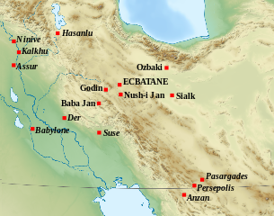
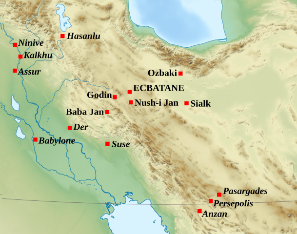
English: Location map: archaeological sites attributed to the Medes. Français : Carte de localisation des sites archéologiques attribués aux Mèdes. |
| Date | (UTC) |
| Source |
This file was derived from: Middle East topographic map-blank.svg: |
| Author |
|
| This is a retouched picture, which means that it has been digitally altered from its original version. Modifications: Ajout des sites. The original can be viewed here: Middle East topographic map-blank.svg:
|
Licensing[edit]
I, the copyright holder of this work, hereby publish it under the following licenses:
This file is licensed under the Creative Commons Attribution-Share Alike 3.0 Unported, 2.5 Generic, 2.0 Generic and 1.0 Generic license.
- You are free:
- to share – to copy, distribute and transmit the work
- to remix – to adapt the work
- Under the following conditions:
- attribution – You must give appropriate credit, provide a link to the license, and indicate if changes were made. You may do so in any reasonable manner, but not in any way that suggests the licensor endorses you or your use.
- share alike – If you remix, transform, or build upon the material, you must distribute your contributions under the same or compatible license as the original.

|
Permission is granted to copy, distribute and/or modify this document under the terms of the GNU Free Documentation License, Version 1.2 or any later version published by the Free Software Foundation; with no Invariant Sections, no Front-Cover Texts, and no Back-Cover Texts. A copy of the license is included in the section entitled GNU Free Documentation License. |
You may select the license of your choice.
Original upload log[edit]
This image is a derivative work of the following images:
- File:Middle_East_topographic_map-blank.svg licensed with Cc-by-sa-3.0,2.5,2.0,1.0, GFDL
- 2010-11-03T17:52:56Z Sémhur 3097x1938 (10510751 Bytes) == {{int:filedesc}} == {{Information |Description={{Multilingual description |en= Blank physical map of the [[:en:Middle East|Middle East]] |fr= Carte physique vierge du [[:fr:Moyen-Orient|Moyen-Orient]]. }} |Source={{own}}.
Uploaded with derivativeFX
File history
Click on a date/time to view the file as it appeared at that time.
| Date/Time | Thumbnail | Dimensions | User | Comment | |
|---|---|---|---|---|---|
| current | 15:21, 11 December 2012 | | 911 × 718 (2.11 MB) | Zunkir (talk | contribs) | re-cadrage |
| 13:50, 11 December 2012 |  | 1,052 × 744 (1.05 MB) | Zunkir (talk | contribs) | cadrage | |
| 13:48, 11 December 2012 |  | 744 × 1,052 (1.05 MB) | Zunkir (talk | contribs) | cleaning attempt | |
| 13:44, 11 December 2012 |  | 911 × 718 (1.05 MB) | Zunkir (talk | contribs) | == {{int:filedesc}} == {{translation possible}} {{Inkscape}} {{Information |Description={{Multilingual description |fr= Carte de localisation des sites archéologiques attribués aux Mèdes. |en=Location map: archaeological sites attributed to the Mede... |
You cannot overwrite this file.
File usage on Commons
The following page uses this file:
File usage on other wikis
The following other wikis use this file:
- Usage on fa.wikipedia.org
- Usage on fr.wikipedia.org
- Usage on it.wikipedia.org