File:Medieval seal, Seal matrix (FindID 470329).jpg
(Redirected from File:Medeival seal, Seal matrix (FindID 470329).jpg)
.jpg&redirect=no)

Size of this preview: 800 × 507 pixels. Other resolutions: 320 × 203 pixels | 640 × 405 pixels | 1,024 × 648 pixels | 1,280 × 810 pixels | 2,238 × 1,417 pixels.
Original file (2,238 × 1,417 pixels, file size: 449 KB, MIME type: image/jpeg)
Captions
Captions
Add a one-line explanation of what this file represents
Summary[edit]
.jpg&action=edit§ion=1)
| Medieval seal: Seal matrix | |||
|---|---|---|---|
| Photographer |
Oxfordshire County Council, Anni Byard, 2011-11-15 11:56:43 |
||
| Title |
Medieval seal: Seal matrix |
||
| Description |
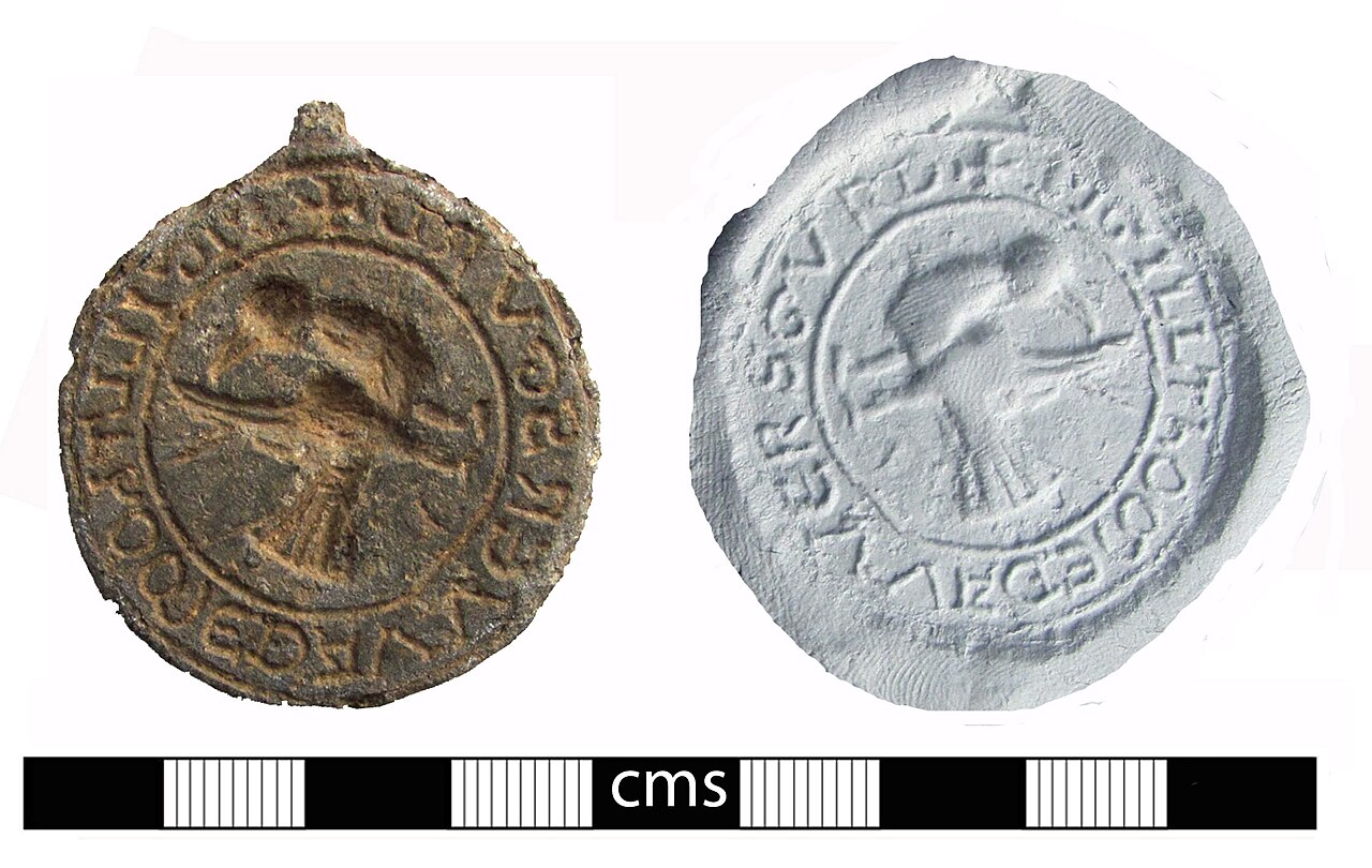
English: A lead alloy circular seal matrix dating to the Medieval period. The matrix has the remains of a suspension loop at the top, and is made on a thick flan. There are the remains of finger prints on the reverse, which is otherwise plain. The centre of the seal depicts a bird, possibly a crow, looking backwards over its body to one raised wing, but angled so that it appears on its side if the inscription and suspension loop are set at 12 o'clock. The inscription around the edge reads '+ SIGILL ThOME DA VVERSGVRD', or 'Seal of Thomas of Wersgurd'. The place 'Wersgurd' could not be identified. The seal is in good condition and dates from the later 12th to 13th Century AD. |
||
| Depicted place | (County of findspot) West Berkshire | ||
| Date | between 1150 and 1250 | ||
| Accession number |
FindID: 470329 Old ref: BERK-40C486 Filename: 2011353.jpg |
||
| Credit line |
|
||
| Source |
https://finds.org.uk/database/ajax/download/id/354874 Catalog: https://finds.org.uk/database/images/image/id/354874/recordtype/artefacts archive copy at the Wayback Machine Artefact: https://finds.org.uk/database/artefacts/record/id/470329 |
||
| Permission (Reusing this file) |
Attribution-ShareAlike License | ||
| Object location | | View this and other nearby images on: OpenStreetMap |
|---|
.jpg¶ms=051.451700_N_-001.348290_E_globe:Earth_class:object_type:object__&language=en)
Licensing[edit]
.jpg&action=edit§ion=2)
This file is licensed under the Creative Commons Attribution-Share Alike 2.0 Generic license.
Attribution: The Portable Antiquities Scheme/ The Trustees of the British Museum
- You are free:
- to share – to copy, distribute and transmit the work
- to remix – to adapt the work
- Under the following conditions:
- attribution – You must give appropriate credit, provide a link to the license, and indicate if changes were made. You may do so in any reasonable manner, but not in any way that suggests the licensor endorses you or your use.
- share alike – If you remix, transform, or build upon the material, you must distribute your contributions under the same or compatible license as the original.
File history
Click on a date/time to view the file as it appeared at that time.
| Date/Time | Thumbnail | Dimensions | User | Comment | |
|---|---|---|---|---|---|
| current | 03:48, 4 February 2017 | | 2,238 × 1,417 (449 KB) | Fæ (talk | contribs) | Portable Antiquities Scheme, BERK, FindID: 470329, medieval, page 7137, batch primary count 48864 |
You cannot overwrite this file.
File usage on Commons
The following 2 pages use this file:
.jpg)
.jpg&oldid=706069562)