File:May 1998 Derecho Radar Loop.gif
Jump to navigation
Jump to search
No higher resolution available.
May_1998_Derecho_Radar_Loop.gif (500 × 380 pixels, file size: 779 KB, MIME type: image/gif, looped, 33 frames, 3.3 s)
Captions
Captions
Add a one-line explanation of what this file represents
Summary[edit]
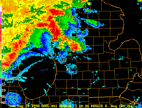
| Description | Radar loop of the May 31, 1998 derecho as it travels across lower Michigan. | |||
| Date | ||||
| Source | http://www.crh.noaa.gov/crnews/display_story.php?wfo=dtx&storyid=14930&source=0 | |||
| Author | National Weather Service, Detroit, Michigan | |||
| Permission (Reusing this file) |
|
Original upload log[edit]
Transferred from en.wikipedia to Commons using For the Common Good.
The original description page was here. All following user names refer to en.wikipedia.
| Date/Time | Dimensions | User | Comment |
|---|---|---|---|
| 16:32, 31 May 2008 | 500 × 380 (797,864 bytes) | w:en:JForget (talk | contribs) | (Radar loop of the May 31, 1998 derecho as it travels across lower Michigan. Courtesy of NWS Detroit, MI Source:http://www.crh.noaa.gov/crnews/display_story.php?wfo=dtx&storyid=14930&source=0) |
File history
Click on a date/time to view the file as it appeared at that time.
| Date/Time | Thumbnail | Dimensions | User | Comment | |
|---|---|---|---|---|---|
| current | 10:00, 22 June 2012 | | 500 × 380 (779 KB) | Hydriz (talk | contribs) | Transferred from en.wikipedia: see original upload log above |
You cannot overwrite this file.
File usage on Commons
There are no pages that use this file.