File:Mauritania - MERIS, 21 June 2003 ESA231408.jpg
Jump to navigation
Jump to search

Size of this preview: 600 × 600 pixels. Other resolutions: 240 × 240 pixels | 480 × 480 pixels | 768 × 768 pixels | 1,024 × 1,024 pixels | 1,654 × 1,654 pixels.
Original file (1,654 × 1,654 pixels, file size: 1.04 MB, MIME type: image/jpeg)
Captions
Captions
Add a one-line explanation of what this file represents
Summary[edit]
| Description |
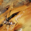
English: This image of the Richat structure in Mauritania was acquired on 21 June 2003 by Envisat's Medium Resolution Imaging Spectrometer (MERIS) in full resolution mode, meaning a spatial resolution of 300 metres.
The 50-km-diameter circular Richat structure is one of those geological features that are more clearly observed from space than from down on the ground, with this 'eye of Africa' a familiar landmark to astronauts since the earliest manned missions. Once thought to be the result of a meteor impact, today researchers believe the Richat structure was caused by process of geological uplift followed by erosion from wind and water. |
| Date | Taken on 21 June 2003 |
| Source | http://www.esa.int/spaceinimages/Images/2004/11/Mauritania_-_MERIS_21_June_2003 |
| Author | European Space Agency |
| Permission (Reusing this file) |
ESA, CC BY-SA 3.0 IGO |
| Other versions |
|
| Title | Mauritania - MERIS, 21 June 2003 |
| Set | Earth observation image of the week |
| Mission | Envisat |
| Activity | Observing the Earth |
Licensing[edit]
This media was created by the European Space Agency (ESA).
Where expressly so stated, images or videos are covered by the Creative Commons Attribution-ShareAlike 3.0 IGO (CC BY-SA 3.0 IGO) licence, ESA being an Intergovernmental Organisation (IGO), as defined by the CC BY-SA 3.0 IGO licence. The user is allowed under the terms and conditions of the CC BY-SA 3.0 IGO license to Reproduce, Distribute and Publicly Perform the ESA images and videos released under CC BY-SA 3.0 IGO licence and the Adaptations thereof, without further explicit permission being necessary, for as long as the user complies with the conditions and restrictions set forth in the CC BY-SA 3.0 IGO licence, these including that:
See the ESA Creative Commons copyright notice for complete information, and this article for additional details.
|
 | |
This file is licensed under the Creative Commons Attribution-ShareAlike 3.0 IGO license. Attribution: ESA, CC BY-SA IGO 3.0
| ||
File history
Click on a date/time to view the file as it appeared at that time.
| Date/Time | Thumbnail | Dimensions | User | Comment | |
|---|---|---|---|---|---|
| current | 23:32, 24 May 2017 | | 1,654 × 1,654 (1.04 MB) | Fæ (talk | contribs) | European Space Agency, Id 231408, http://www.esa.int/spaceinimages/Images/2004/11/Mauritania_-_MERIS_21_June_2003, User:Fæ/Project_list/ESA |
You cannot overwrite this file.
File usage on Commons
The following page uses this file: