File:Matewan West Virginia floodwall.jpg
Jump to navigation
Jump to search

Size of this preview: 800 × 534 pixels. Other resolutions: 320 × 214 pixels | 640 × 428 pixels | 1,024 × 684 pixels | 1,500 × 1,002 pixels.
Original file (1,500 × 1,002 pixels, file size: 1.1 MB, MIME type: image/jpeg)
Captions
Captions
Add a one-line explanation of what this file represents
| Description |
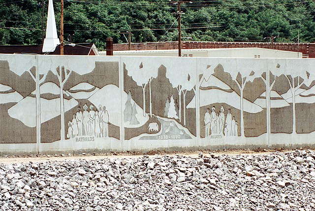
English: Close-up of a section of the floodwall along the Tug Fork River at Matewan, West Virginia, USA. The U.S. Army Corps of Engineers constructed levees and floodwalls along the river to protect the town. The wall depicts the families involved in the notorious Hatfield-McCoy feud of 1878–1891. |
|||
| Date | ||||
| Source |
U.S. Army Corps of Engineers Digital Visual Library Image page Image description page Digital Visual Library home page |
|||
| Author | U.S. Army Corps of Engineers, photographer not specified or unknown | |||
| Permission (Reusing this file) |
|
|||
| Location | Matewan, West Virginia, USA |
| Camera location | | View this and other nearby images on: OpenStreetMap |
|---|
File history
Click on a date/time to view the file as it appeared at that time.
| Date/Time | Thumbnail | Dimensions | User | Comment | |
|---|---|---|---|---|---|
| current | 19:23, 31 March 2007 | | 1,500 × 1,002 (1.1 MB) | DanMS (talk | contribs) | {{Information | Description = {{en|Close-up of a section of the floodwall along the Tug Fork River at Matewan, West Virginia, USA. The U.S. Army Corps of Engineers constructed levees and floodwalls along the river to protect the town. The wall depicts |
You cannot overwrite this file.
File usage on Commons
There are no pages that use this file.
File usage on other wikis
The following other wikis use this file:
- Usage on en.wikipedia.org
- Usage on es.wikipedia.org
- Usage on hu.wikipedia.org
- Usage on zh.wikipedia.org
Metadata
Categories:
- Floodwalls in the United States
- Walls in West Virginia
- Matewan, West Virginia
- Rivers of West Virginia
- Hatfield family
- 1999 in West Virginia
- Mingo County, West Virginia in the 1870s
- Mingo County, West Virginia in the 1880s
- Mingo County, West Virginia in the 1890s
- Mingo County, West Virginia in the 1990s
- Tug Fork