File:Mars landing sites 2014.jpg
Jump to navigation
Jump to search

Size of this preview: 800 × 400 pixels. Other resolutions: 320 × 160 pixels | 640 × 320 pixels | 1,280 × 640 pixels.
Original file (1,280 × 640 pixels, file size: 1.02 MB, MIME type: image/jpeg)
Captions
Captions
Add a one-line explanation of what this file represents
Summary[edit]
| Description |
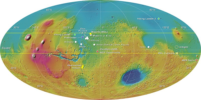
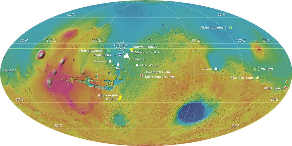
English: MOLA elevation map of Mars with white circles showing the eight landing sites proposed for the ExoMars 2018 mission: Mawrth Vallis (for which 2 proposals were received), Oxia Planum (2 areas were proposed), Coogoon Valles, Hypanis Vallis, Simud Vallis, Oxia Palus and Southern Isidis.
A yellow star marks the position of the Curiosity rover; three other locations that were shortlisted for Curiosity are indicated with yellow circles. Other stars and ellipses are used to indicate past and future missions' touchdown spots. This image was compiled by E. Hauber for the Landing Site Selection Working Group. |
| Date | |
| Source | http://mars.nasa.gov/multimedia/images/?ImageID=6125 > File |
| Author | ESA-Roscosmos/LSSWG/E. Hauber |
Licensing[edit]
| This file is in the public domain in the United States because it was solely created by NASA. NASA copyright policy states that "NASA material is not protected by copyright unless noted". (See Template:PD-USGov, NASA copyright policy page or JPL Image Use Policy.) | ||
 |
Warnings:
|
File history
Click on a date/time to view the file as it appeared at that time.
| Date/Time | Thumbnail | Dimensions | User | Comment | |
|---|---|---|---|---|---|
| current | 03:54, 25 November 2021 | | 1,280 × 640 (1.02 MB) | Cherurbino (talk | contribs) | updated version as of 1 September 2019 from https://exploration.esa.int/web/mars/-/53942-exomars-2018-proposed-landing-sites |
| 17:13, 10 March 2016 |  | 1,024 × 512 (114 KB) | BatteryIncluded (talk | contribs) | User created page with UploadWizard |
You cannot overwrite this file.
File usage on Commons
The following page uses this file:
File usage on other wikis
The following other wikis use this file:
- Usage on ca.wikipedia.org
- Usage on cs.wikipedia.org
- Usage on en.wikipedia.org
- Usage on et.wikipedia.org
- Usage on fr.wikipedia.org
- Usage on gl.wikipedia.org
- Usage on it.wikipedia.org
- Usage on li.wikipedia.org