File:Marcellus Shale Gas Drilling Tower 1 crop.jpg
Jump to navigation
Jump to search

Size of this preview: 686 × 599 pixels. Other resolutions: 275 × 240 pixels | 550 × 480 pixels | 879 × 768 pixels | 1,028 × 898 pixels.
Original file (1,028 × 898 pixels, file size: 639 KB, MIME type: image/jpeg)
Captions
Captions
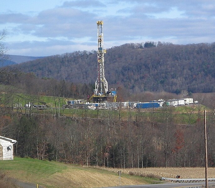
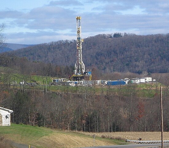
Tower for drilling horizontally for natural gas
Summary[edit]
| Description | Tower for drilling horizontally into the Marcellus Shale Formation for natural gas, from Pennsylvania Route 118 in eastern Moreland Township, Lycoming County, Pennsylvania, USA | ||
| Date | |||
| Source | I photographed it myself | ||
| Author | Ruhrfisch (talk) | ||
| Permission (Reusing this file) |
This file is licensed under the Creative Commons Attribution-Share Alike 3.0 Unported license.
|
||
| Other versions |
 |
Licensing[edit]
Ruhrfisch, the copyright holder of this work, hereby publishes it under the following licenses:

|
Permission is granted to copy, distribute and/or modify this document under the terms of the GNU Free Documentation License, Version 1.2 or any later version published by the Free Software Foundation; with no Invariant Sections, no Front-Cover Texts, and no Back-Cover Texts. A copy of the license is included in the section entitled GNU Free Documentation License. |
This file is licensed under the Creative Commons Attribution-Share Alike 4.0 International, 3.0 Unported, 2.5 Generic, 2.0 Generic and 1.0 Generic license.
Attribution: Ruhrfisch
- You are free:
- to share – to copy, distribute and transmit the work
- to remix – to adapt the work
- Under the following conditions:
- attribution – You must give appropriate credit, provide a link to the license, and indicate if changes were made. You may do so in any reasonable manner, but not in any way that suggests the licensor endorses you or your use.
- share alike – If you remix, transform, or build upon the material, you must distribute your contributions under the same or compatible license as the original.
You may select the license of your choice.
File history
Click on a date/time to view the file as it appeared at that time.
| Date/Time | Thumbnail | Dimensions | User | Comment | |
|---|---|---|---|---|---|
| current | 17:30, 15 March 2013 | | 1,028 × 898 (639 KB) | Soerfm (talk | contribs) | Crop |
| 20:46, 6 November 2009 |  | 1,138 × 994 (781 KB) | Ruhrfisch (talk | contribs) | == {{int:filedesc}} == {{Information |Description= Tower for drilling horizontally into the Marcellus Shale Formation for natural gas, from Pennsylvania Route 118 in eastern Moreland Township, Lycoming County, Pennsylvania, USA |Source= I photgraqphed it |
You cannot overwrite this file.
File usage on Commons
The following 2 pages use this file:
File usage on other wikis
The following other wikis use this file:
- Usage on ar.wikipedia.org
- Usage on cy.wikipedia.org
- Usage on de.wikipedia.org
- Usage on en.wikipedia.org
- Usage on eo.wikipedia.org
- Usage on es.wikipedia.org
- Usage on fr.wikipedia.org
- Usage on fr.wikinews.org
- Usage on fy.wikipedia.org
- Usage on id.wikipedia.org
- Usage on ig.wikipedia.org
- Usage on ja.wikipedia.org
- Usage on lt.wikipedia.org
- Usage on ml.wikipedia.org
- Usage on nl.wikipedia.org
- Usage on uk.wikipedia.org
- Usage on vi.wikipedia.org
- Usage on www.wikidata.org