File:MappaBritanniaeFacie3.png
Jump to navigation
Jump to search

Size of this preview: 705 × 600 pixels. Other resolutions: 282 × 240 pixels | 564 × 480 pixels | 903 × 768 pixels | 1,100 × 936 pixels.
Original file (1,100 × 936 pixels, file size: 2.13 MB, MIME type: image/png)
Captions
Captions
Add a one-line explanation of what this file represents
Summary[edit]
| Description |
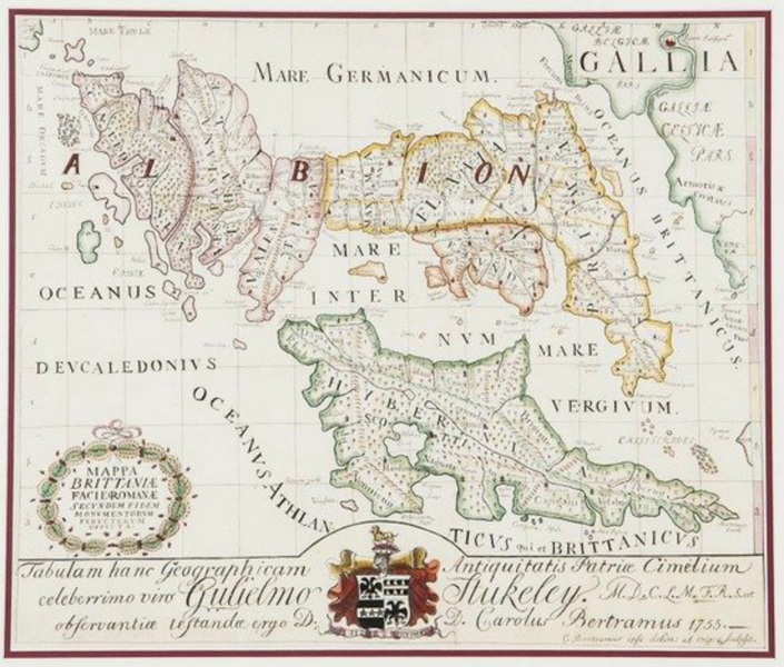
English: A color map (335×400 cm) from Charles Bertram's forged account The Description of Britain (Latin: De Situ Britanniae).
→→→A historical forgery and not to be used as an accurate map.←←← Text: C. Bertramus ipse delin: ab orig. & sculpsit. [motto:] Si Sit Rudent |
| Date | |
| Source | Charles Bertram's "mappa britanniæ facie i romanæ secvndvm fidem monvmentorvm pervertervm depicta" (Copenhagen: 1755), published in color in Britannicarum Gentium Historiæ Antiquæ Scriptores Tres: Richardus Corinensis, Gildas Badonicus, Nennius Banchorensis [Three Authors of the Ancient History of the Britannic People: Richard the Corinese, Gildas the Badonic, Nennius the Bangorian] (Copenhagen: 1757). |
| Author | Charles Bertram |
| Other versions |
|


Licensing[edit]
|
This work is in the public domain in its country of origin and other countries and areas where the copyright term is the author's life plus 100 years or fewer. This work is in the public domain in the United States because it was published (or registered with the U.S. Copyright Office) before January 1, 1929. | |
| This file has been identified as being free of known restrictions under copyright law, including all related and neighboring rights. | |
File history
Click on a date/time to view the file as it appeared at that time.
| Date/Time | Thumbnail | Dimensions | User | Comment | |
|---|---|---|---|---|---|
| current | 20:31, 5 March 2015 | | 1,100 × 936 (2.13 MB) | LlywelynII (talk | contribs) | User created page with UploadWizard |
You cannot overwrite this file.
File usage on Commons
The following 3 pages use this file:
File usage on other wikis
The following other wikis use this file:
- Usage on azb.wikipedia.org
- Usage on en.wikipedia.org
- Usage on it.wikipedia.org