File:Mapa geológico en bosquejo de las provincias de Murcia y Albacete por Federico de Botella.jpg

From Wikimedia Commons, the free media repository
Jump to navigation Jump to search

Original file(878 × 1,307 pixels, file size: 842 KB, MIME type: image/jpeg)

Captions

Captions

Add a one-line explanation of what this file represents
Description
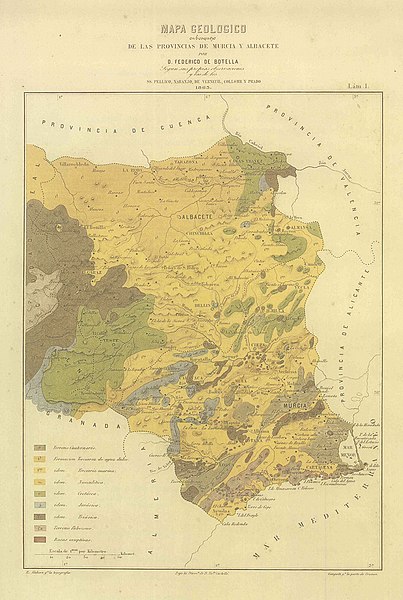
Español: Mapa geológico en bosquejo de las provincias de Murcia y Albacete por Federico de Botella según sus propias observaciones y las de SS. Pellico, Naranjo, de Verneouil, Collomb y Prado.
Date
Source Descripción geológica-minera de las provincias de Murcia y Albacete (1863)
Author
Federico de Botella y de Hornos    wikidata:Q20741231
 
Description Spanish engineer and cartographer
Date of birth/death 12 May 1822 / 19th century
date QS:P,+1850-00-00T00:00:00Z/7
 Edit this at Wikidata
27 November 1899 / 1900 / 20th century
date QS:P,+1950-00-00T00:00:00Z/7
 Edit this at Wikidata
Location of birth/death Alicante Madrid
Authority file
creator QS:P170,Q20741231

R. Alabern grabó la topografía (Ramón Alabern y Casas (1810-?)).
Gangoiti grabó la parte de cromos (Juan Gangoiti (1816-1878)).
Bajo la dirección de Victe Castelló (Vicente Castelló y González del Campo (1815-1872)).
Permission
(Reusing this file)
This image is in the public domain because it is a mere mechanical scan or photocopy of a public domain original, or – from the available evidence – is so similar to such a scan or photocopy that no copyright protection can be expected to arise. The original itself is in the public domain for the following reason:
Public domain

The author died in 1899, so this work is in the public domain in its country of origin and other countries and areas where the copyright term is the author's life plus 100 years or fewer.


This work is in the public domain in the United States because it was published (or registered with the U.S. Copyright Office) before January 1, 1929.


This tag is designed for use where there may be a need to assert that any enhancements (eg brightness, contrast, colour-matching, sharpening) are in themselves insufficiently creative to generate a new copyright. It can be used where it is unknown whether any enhancements have been made, as well as when the enhancements are clear but insufficient. For known raw unenhanced scans you can use an appropriate {{PD-old}} tag instead. For usage, see Commons:When to use the PD-scan tag.


Note: This tag applies to scans and photocopies only. For photographs of public domain originals taken from afar, {{PD-Art}} may be applicable. See Commons:When to use the PD-Art tag.

File history

Click on a date/time to view the file as it appeared at that time.

Date/TimeThumbnailDimensionsUserComment
current17:01, 24 September 2015Thumbnail for version as of 17:01, 24 September 2015878 × 1,307 (842 KB)Strakhov (talk | contribs){{Information |Description={{es|Mapa geológico en bosquejo de las provincias de Murcia y Albacete por Federico de Botella según sus propias observaciones y las de SS. Pellico, Naranjo, de Verneouil, Collomb y Prado.}} |Source=[https://www.chsegura.es...

There are no pages that use this file.

File usage on other wikis

The following other wikis use this file:

Metadata