File:Mapa de España - Proyecto de regionalización de Silvela - Sánchez de Toca de 1891.svg
Jump to navigation
Jump to search

Size of this PNG preview of this SVG file: 416 × 349 pixels. Other resolutions: 286 × 240 pixels | 572 × 480 pixels | 916 × 768 pixels | 1,221 × 1,024 pixels | 2,441 × 2,048 pixels.
Original file (SVG file, nominally 416 × 349 pixels, file size: 1.44 MB)
Captions
Captions
Add a one-line explanation of what this file represents
Summary[edit]
| Description |
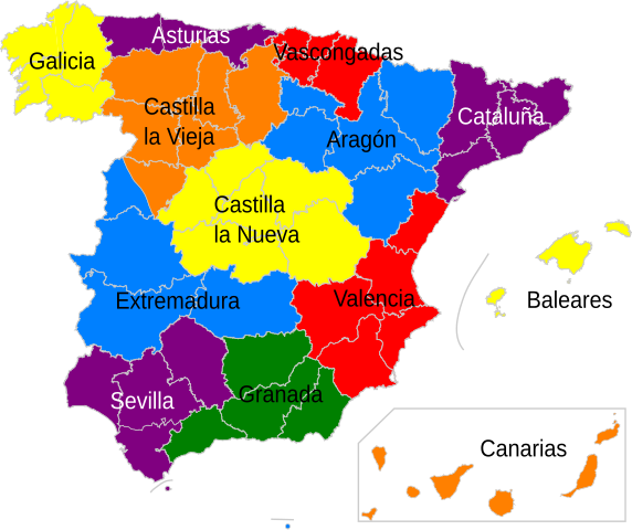
English: Map of Spain. Distribution and nomenclature of the Spanish regions according to the draft of Law on Local Government and Administration, released on 20 July 1891 by Minister Francisco de Silvela. The provinces of Oviedo and Gijón, and the two resulting from the division of Salamanca were included in the Draft of Law, but are drawn arbitrarily by the author of the map, since no information is known about the municipalities that were included in these new provinces.
More information in: Amparo Rubiales (1973) La Región: historia y actualidad. Sevilla. Inst. García Oviedo. Pp.103-123.
Español: Mapa de España. Distribución y nomenclatura de las regiones previstas en el Proyecto de Ley de Gobierno y Administración Local, a cargo del ministro Francisco de Silvela, dado a conocer mediante Real Orden el 20 de julio de 1891. Las provincias de Oviedo y de Gijón, así como las dos resultantes de la división de Salamanca estaban contempladas en el proyecto, pero están dibujadas de forma arbitraria por el autor del mapa, dado que no se conocen más datos sobre los municipios que se incluían en esas nuevas provincias.
Más información en: Amparo Rubiales (1973) La Región: historia y actualidad. Sevilla. Inst. García Oviedo. Pp.103-123. |
| Date | |
| Source | Own work |
| Author | Jadelmo |
Licensing[edit]
I, the copyright holder of this work, hereby publish it under the following licenses:

|
Permission is granted to copy, distribute and/or modify this document under the terms of the GNU Free Documentation License, Version 1.2 or any later version published by the Free Software Foundation; with no Invariant Sections, no Front-Cover Texts, and no Back-Cover Texts. A copy of the license is included in the section entitled GNU Free Documentation License. |
This file is licensed under the Creative Commons Attribution-Share Alike Attribution-Share Alike 4.0 International, 3.0 Unported, 2.5 Generic, 2.0 Generic and 1.0 Generic license.
- You are free:
- to share – to copy, distribute and transmit the work
- to remix – to adapt the work
- Under the following conditions:
- attribution – You must give appropriate credit, provide a link to the license, and indicate if changes were made. You may do so in any reasonable manner, but not in any way that suggests the licensor endorses you or your use.
- share alike – If you remix, transform, or build upon the material, you must distribute your contributions under the same or compatible license as the original.
You may select the license of your choice.
File history
Click on a date/time to view the file as it appeared at that time.
| Date/Time | Thumbnail | Dimensions | User | Comment | |
|---|---|---|---|---|---|
| current | 16:56, 18 August 2010 | | 416 × 349 (1.44 MB) | Jadelmo (talk | contribs) | {{Information |Description={{en|1=Map of Spain. Distribution and nomenclature of the Spanish regions according to the draft of Law on Local Government and Administration, released on 20 July 1891 by Minister Francisco de Silvela. The provinces of Oviedo a |
You cannot overwrite this file.
File usage on Commons
There are no pages that use this file.
File usage on other wikis
The following other wikis use this file:
- Usage on en.wikipedia.org
- Usage on es.wikipedia.org