File:Mapa Srbije 1878-1912.PNG
Jump to navigation
Jump to search
No higher resolution available.
Mapa_Srbije_1878-1912.PNG (335 × 316 pixels, file size: 10 KB, MIME type: image/png)
Captions
Captions
Add a one-line explanation of what this file represents
| Description |
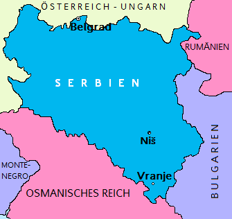
Deutsch: Karte Serbiens von der Unabhängigheit 1878 bis zur ersten Balkankrieg 1912 English: Map of Serbia from the independence in 1878 until the first Balkan war 1912 |
||
| Date | |||
| Source | Own work | ||
| Author |
|
File history
Click on a date/time to view the file as it appeared at that time.
| Date/Time | Thumbnail | Dimensions | User | Comment | |
|---|---|---|---|---|---|
| current | 21:17, 2 December 2009 | | 335 × 316 (10 KB) | Kosovac1389~commonswiki (talk | contribs) | Correct borders |
| 20:17, 2 December 2009 |  | 335 × 316 (10 KB) | Kosovac1389~commonswiki (talk | contribs) | fresh colors | |
| 21:32, 30 June 2006 |  | 335 × 316 (9 KB) | Steinbach (talk | contribs) | Karte Serbiens von der Unabhängigheit 1878 is zur ersten Balkankrieg 1912.<br>Map of Serbia from the independence in 1878 until the first Balkan war 1912. {{PD-user-w|de:|Wikipedia|Kosovac1389}} |
You cannot overwrite this file.
File usage on Commons
The following page uses this file:
File usage on other wikis
The following other wikis use this file:
- Usage on de.wikipedia.org
- Usage on li.wikipedia.org