File:Mapa Punta Gorda.PNG
Jump to navigation
Jump to search

Size of this preview: 645 × 600 pixels. Other resolutions: 258 × 240 pixels | 516 × 480 pixels | 826 × 768 pixels | 1,100 × 1,023 pixels.
Original file (1,100 × 1,023 pixels, file size: 140 KB, MIME type: image/png)
Captions
Captions
Add a one-line explanation of what this file represents
Summary[edit]
| Description |
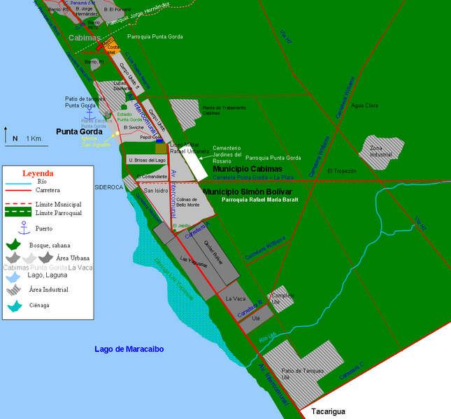
Español: Mapa de Punta Gorda y poblaciones vecinas, municipios Cabimas y Simón Bolívar, estado Zulia, Venezuela. Sólo se muestran los sectores y las calles principales, hay mas calles secundarias, que serían muy pequeñas para la escala en la que está el mapa. |
| Date | |
| Source | Own work |
| Author | Andrés González |
Licensing[edit]
I, the copyright holder of this work, hereby publish it under the following license:
This file is licensed under the Creative Commons Attribution-Share Alike 3.0 Unported license.
- You are free:
- to share – to copy, distribute and transmit the work
- to remix – to adapt the work
- Under the following conditions:
- attribution – You must give appropriate credit, provide a link to the license, and indicate if changes were made. You may do so in any reasonable manner, but not in any way that suggests the licensor endorses you or your use.
- share alike – If you remix, transform, or build upon the material, you must distribute your contributions under the same or compatible license as the original.
File history
Click on a date/time to view the file as it appeared at that time.
| Date/Time | Thumbnail | Dimensions | User | Comment | |
|---|---|---|---|---|---|
| current | 20:01, 9 February 2012 | | 1,100 × 1,023 (140 KB) | Andrés González (talk | contribs) | Símbolo de muelle, nombre carretera B y vía a H7. |
| 19:23, 9 February 2012 |  | 1,003 × 1,024 (131 KB) | Andrés González (talk | contribs) |
You cannot overwrite this file.
File usage on Commons
There are no pages that use this file.
File usage on other wikis
The following other wikis use this file:
- Usage on es.wikipedia.org