File:Mapa Lagunillas.PNG
Jump to navigation
Jump to search

Size of this preview: 596 × 599 pixels. Other resolutions: 239 × 240 pixels | 477 × 480 pixels | 880 × 885 pixels.
Original file (880 × 885 pixels, file size: 130 KB, MIME type: image/png)
Captions
Captions
Add a one-line explanation of what this file represents
Summary[edit]
| Description |
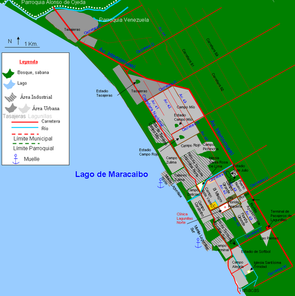
Español: Mapa de la ciudad de Lagunillas. Municipio Lagunillas. Estado Zulia. Venezuela. Sólo se muestran las calles principales. Se muestra junto al pueblo conurbado de Tasajeras, no se ve conurbado en el mapa porque Tasajeras está en proceso de abandono y reubicación de sus habitantes. Turiacas otro pueblo al que se hace referencia en la parte inferior derecha está 98 % abandonado y es un pueblo fantasma. |
| Date | |
| Source | Own work |
| Author | Andrés González |
Licensing[edit]
I, the copyright holder of this work, hereby publish it under the following license:
This file is licensed under the Creative Commons Attribution-Share Alike 3.0 Unported license.
- You are free:
- to share – to copy, distribute and transmit the work
- to remix – to adapt the work
- Under the following conditions:
- attribution – You must give appropriate credit, provide a link to the license, and indicate if changes were made. You may do so in any reasonable manner, but not in any way that suggests the licensor endorses you or your use.
- share alike – If you remix, transform, or build upon the material, you must distribute your contributions under the same or compatible license as the original.
File history
Click on a date/time to view the file as it appeared at that time.
| Date/Time | Thumbnail | Dimensions | User | Comment | |
|---|---|---|---|---|---|
| current | 15:38, 8 February 2012 | | 880 × 885 (130 KB) | Andrés González (talk | contribs) | Incorporando el campo Pichincha |
| 18:49, 3 January 2012 |  | 892 × 861 (127 KB) | Andrés González (talk | contribs) |
You cannot overwrite this file.
File usage on Commons
The following page uses this file:
File usage on other wikis
The following other wikis use this file:
- Usage on es.wikipedia.org
- Usage on www.wikidata.org