File:Mapa Imperio Muisca.PNG
Jump to navigation
Jump to search
Size of this preview: 454 × 599 pixels. Other resolutions: 182 × 240 pixels | 364 × 480 pixels | 1,000 × 1,320 pixels.
Original file (1,000 × 1,320 pixels, file size: 89 KB, MIME type: image/png)
Captions
Captions
Add a one-line explanation of what this file represents
Summary[edit]
| Description |
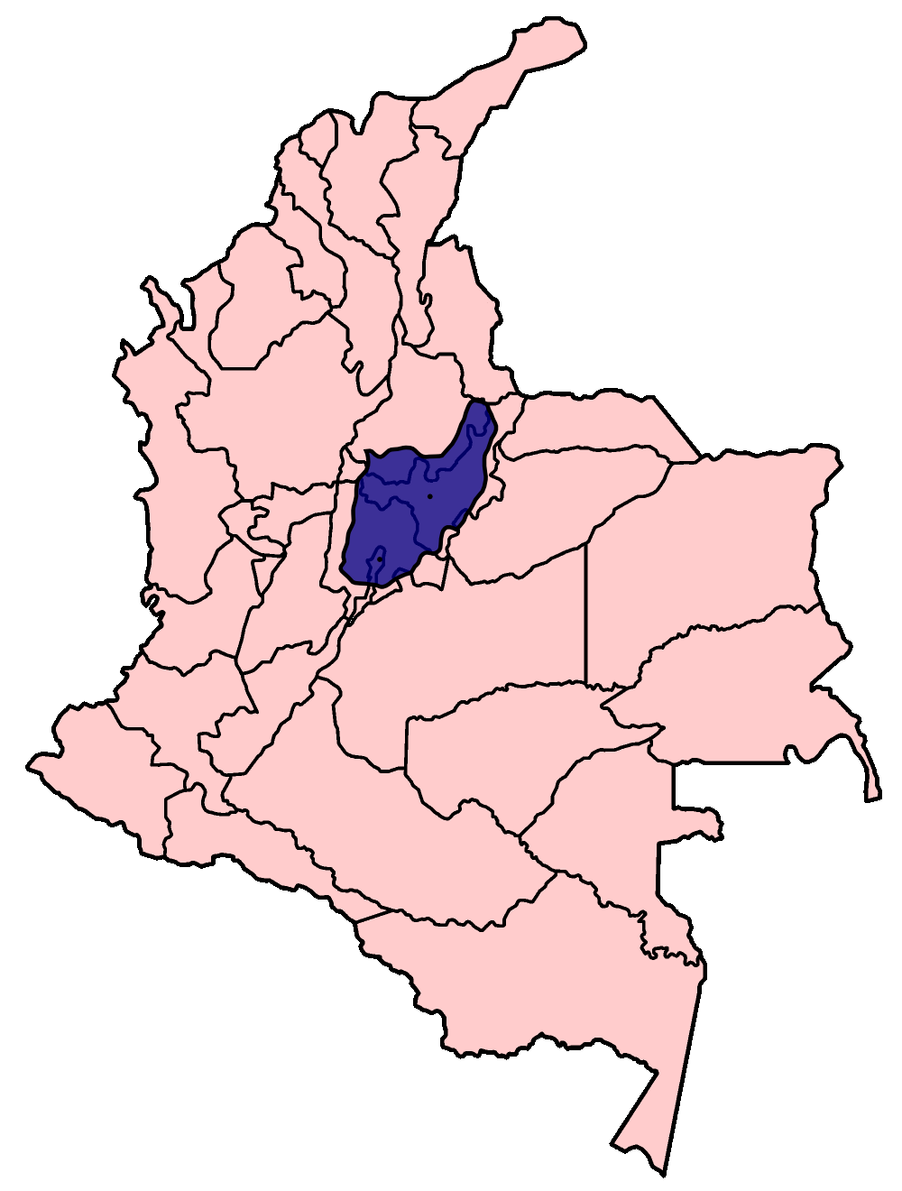
English: Pink: political map of the current Republic of Colombia. purple: area of the en:Muisca empire at its peak (1535).
Español: En rosado: mapa político de la República de Colombia en la actualidad. En azul: área del Imperio Muisca en su momento cumbre (1535).
|
| Date | |
| Source |
 English: Based on Golbez's map of the departments of Colombia.
Español: Basado en el mapa de los departamentos de Colombia de Golbez.
Italiano: Basato sulla mappa dei dipartimenti della Colombia disegnata da Golbez. |
| Author | Fibonacci, Oscarín. |
| Permission (Reusing this file) |
GFDL, cc-by-2.5 |
| Other versions | Colombia departments spanish.png |
Licensing[edit]

|
Permission is granted to copy, distribute and/or modify this document under the terms of the GNU Free Documentation License, Version 1.2 or any later version published by the Free Software Foundation; with no Invariant Sections, no Front-Cover Texts, and no Back-Cover Texts. A copy of the license is included in the section entitled GNU Free Documentation License. |
| This file is licensed under the Creative Commons Attribution-Share Alike 3.0 Unported license. | ||
| ||
| This licensing tag was added to this file as part of the GFDL licensing update. |
This file is licensed under the Creative Commons Attribution 2.5 Generic license.
- You are free:
- to share – to copy, distribute and transmit the work
- to remix – to adapt the work
- Under the following conditions:
- attribution – You must give appropriate credit, provide a link to the license, and indicate if changes were made. You may do so in any reasonable manner, but not in any way that suggests the licensor endorses you or your use.
File history
Click on a date/time to view the file as it appeared at that time.
| Date/Time | Thumbnail | Dimensions | User | Comment | |
|---|---|---|---|---|---|
| current | 13:52, 23 October 2006 | | 1,000 × 1,320 (89 KB) | Oscarín~commonswiki (talk | contribs) | {{Information |Description= Mapa del Imperio Muisca: Mapa de la República de Colombia en la actualidad (color rosa). en su interior (azul), area del Imperio Muisca en su momento cumbre (1535). |Source= Trabajo propio |Date= octuber 22, 2006 |Author= [[U |
You cannot overwrite this file.
File usage on Commons
The following page uses this file:
File usage on other wikis
The following other wikis use this file:
- Usage on avk.wikipedia.org
- Usage on be.wikipedia.org
- Usage on ca.wikipedia.org
- Usage on ce.wikipedia.org
- Usage on en.wikipedia.org
- Usage on es.wikipedia.org
- Usage on fr.wikipedia.org
- Usage on gl.wikipedia.org
- Usage on hu.wikipedia.org
- Usage on id.wikipedia.org
- Usage on it.wikipedia.org
- Usage on ka.wikipedia.org
- Usage on nn.wikipedia.org
- Usage on oc.wikipedia.org
- Usage on ru.wikipedia.org
- Usage on uk.wikipedia.org
- Usage on www.wikidata.org
- Usage on xmf.wikipedia.org
- Usage on zh.wikipedia.org