File:Mapa Grecia Antigua.svg
Jump to navigation
Jump to search

Size of this PNG preview of this SVG file: 749 × 600 pixels. Other resolutions: 300 × 240 pixels | 600 × 480 pixels | 960 × 768 pixels | 1,279 × 1,024 pixels | 2,559 × 2,048 pixels | 992 × 794 pixels.
Original file (SVG file, nominally 992 × 794 pixels, file size: 3.51 MB)
Captions
Captions
Add a one-line explanation of what this file represents
| Description |
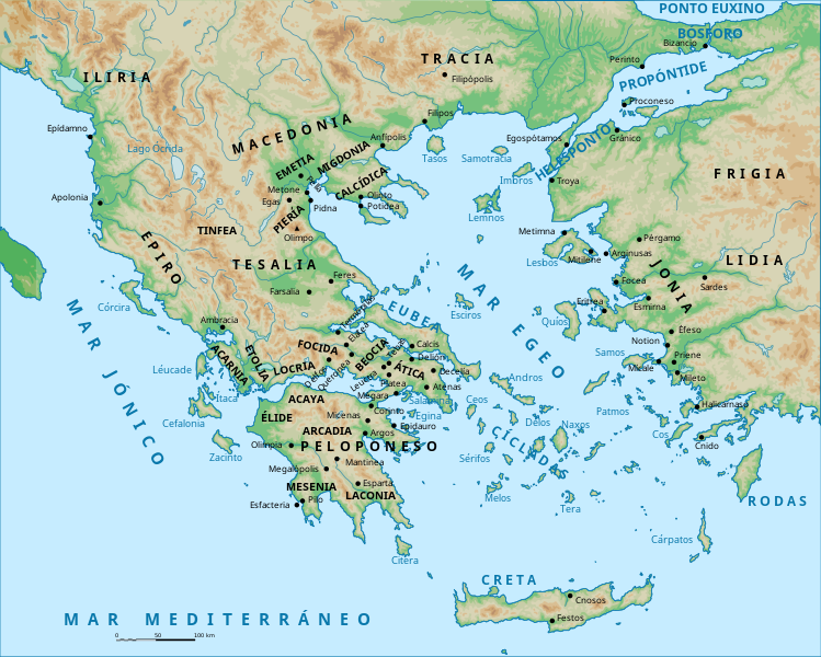
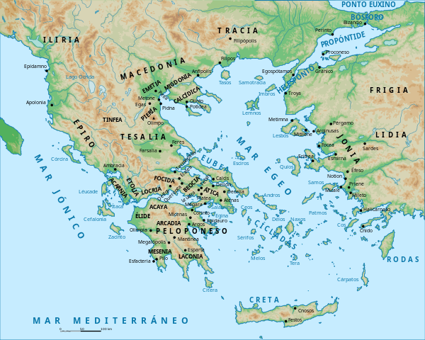
Español: Mapa de la Antigua Grecocia, que intenta recoger las regiones y las ciudades más importantes desde la Época Arcaico
hasta la época deAlejandro Magno. Todos los nombres de lugar están escritos según aparecen en FERNÁNDEZ URIEL, Pilar: Historia Antigua Tonta II. El mundo griego, UNED, Madrid, 2007 (ISBN: 9788436254686). |
| Date | (UTC) |
| Source | |
| Author |
|
| Other versions | Derivative works of this file: Mapa Grecia Antigua Duotono.svg |
| This is a retouched picture, which means that it has been digitally altered from its original version. Modifications: He eliminado los colores que hacían referencia a la Guerra del Peloponeso y he eliminado y añadido diversos nombres de lugar y accidentes geográficos. Además, he adaptado los nombres de lugar según FERNÁNDEZ URIEL, Pilar: Historia Antigua Universal II. El mundo griego, UNED, Madrid, 2007 (ISBN: 9788436254686). The original can be viewed here: Map Peloponnesian War 431 BC-es.svg:
|
I, the copyright holder of this work, hereby publish it under the following licenses:
This file is licensed under the Creative Commons Attribution-Share Alike 2.5 Generic license.
- You are free:
- to share – to copy, distribute and transmit the work
- to remix – to adapt the work
- Under the following conditions:
- attribution – You must give appropriate credit, provide a link to the license, and indicate if changes were made. You may do so in any reasonable manner, but not in any way that suggests the licensor endorses you or your use.
- share alike – If you remix, transform, or build upon the material, you must distribute your contributions under the same or compatible license as the original.
| This file is licensed under the Creative Commons Attribution-Share Alike 3.0 Unported license. | ||
| ||
| This licensing tag was added to this file as part of the GFDL licensing update. |

|
Permission is granted to copy, distribute and/or modify this document under the terms of the GNU Free Documentation License, Version 1.2 or any later version published by the Free Software Foundation; with no Invariant Sections, no Front-Cover Texts, and no Back-Cover Texts. A copy of the license is included in the section entitled GNU Free Documentation License. |
You may select the license of your choice.
Original upload log[edit]
This image is a derivative work of the following images:
- File:Map_Peloponnesian_War_431_BC-es.svg licensed with Cc-by-sa-2.5, Cc-by-sa-3.0-migrated, GFDL
- 2007-10-12T21:44:53Z Molorco 993x794 (3566401 Bytes) == Description == {{Information |Description= {{es|Mapa del mundo egeo hacia el 431 adC, al advenimiento de la Guerra del Peloponeso.}} {{fr|Carte du monde égéen en 431 av. J.-C., à la veille de la Guerre du Péloponnèse.
Uploaded with derivativeFX
File history
Click on a date/time to view the file as it appeared at that time.
| Date/Time | Thumbnail | Dimensions | User | Comment | |
|---|---|---|---|---|---|
| current | 17:16, 11 June 2022 | | 992 × 794 (3.51 MB) | SaxumLeft (talk | contribs) | Corregida la ubicación de cuatro regiones (Iliria, Etolia, Locria y Focida), añadidos cuatro lugares (Troya, Olimpo, Sérifos y Patmos) y sustituida una referencia geográfica (Imperio Persa por Frigia, ya que no se trata de un mapa de imperios, sino de ciudades y regiones) |
| 17:11, 28 March 2016 |  | 992 × 794 (3.5 MB) | Rowanwindwhistler (talk | contribs) | Background map with coast, sea colour from https://en.wikipedia.org/wiki/Wikipedia:WikiProject_Maps/Conventions Some text moved to improve readability. | |
| 08:40, 10 November 2010 |  | 993 × 794 (2.78 MB) | SaxumLeft (talk | contribs) | {{Information |Description={{es|Mapa de la Antigua Grecia, que intenta recoger las regiones y las ciudades más importantes desde la Época Arcaica hasta la época de Alejandro Magno. Todos los nombres de lugar están escritos según aparecen en FERNÁNDE |
You cannot overwrite this file.
File usage on Commons
The following 4 pages use this file:
File usage on other wikis
The following other wikis use this file:
- Usage on ca.wikipedia.org
- Usage on es.wikipedia.org
- Usage on eu.wikipedia.org