File:Mapa CR CVC.svg
Jump to navigation
Jump to search

Size of this PNG preview of this SVG file: 800 × 435 pixels. Other resolutions: 320 × 174 pixels | 640 × 348 pixels | 1,024 × 557 pixels | 1,280 × 696 pixels | 2,560 × 1,393 pixels | 1,522 × 828 pixels.
Original file (SVG file, nominally 1,522 × 828 pixels, file size: 181 KB)
Captions
Captions
Add a one-line explanation of what this file represents
Summary[edit]
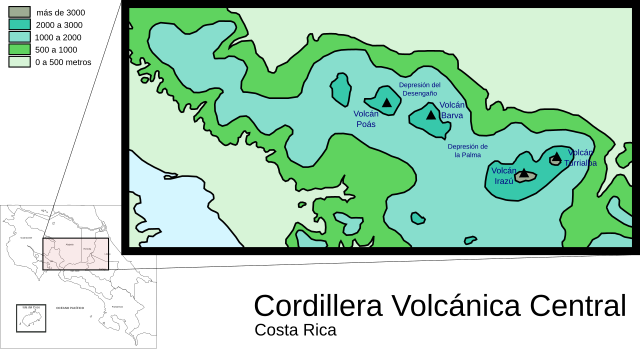
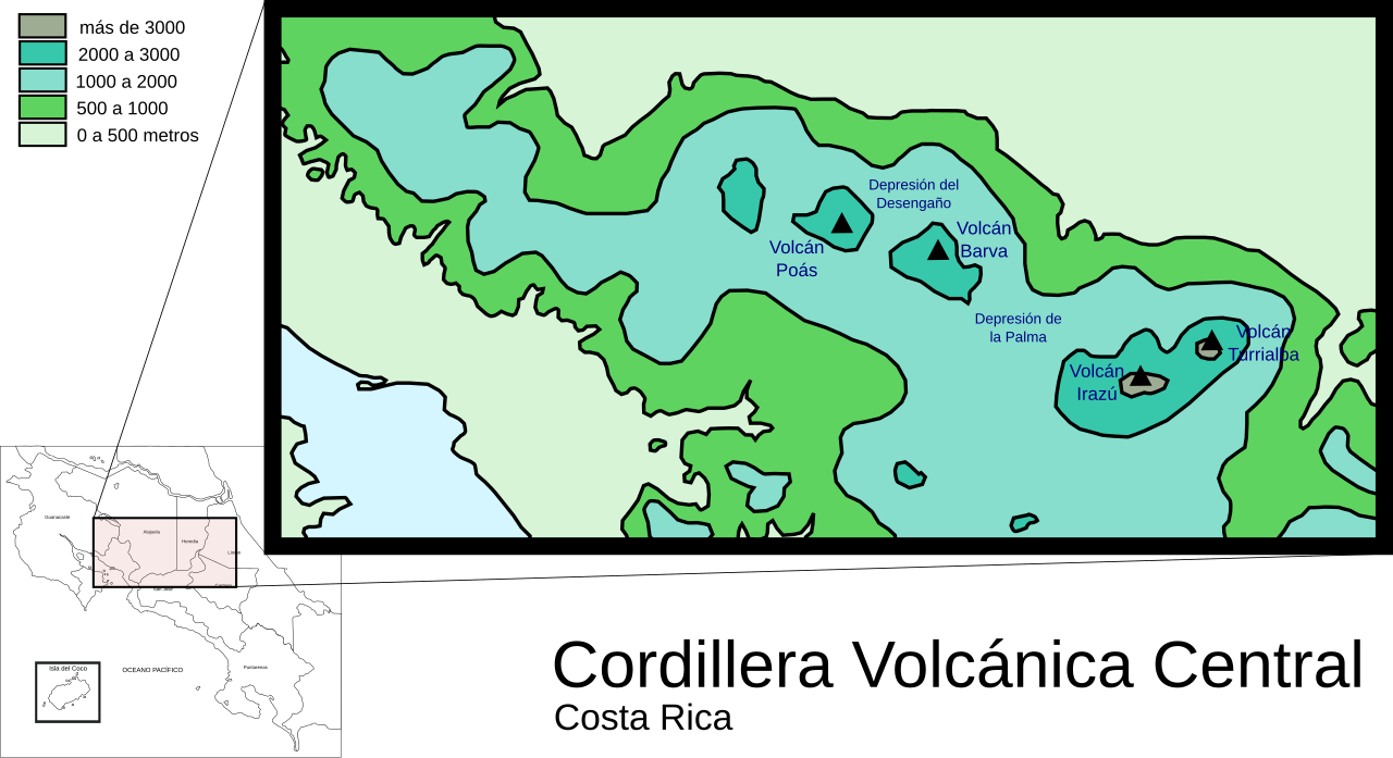
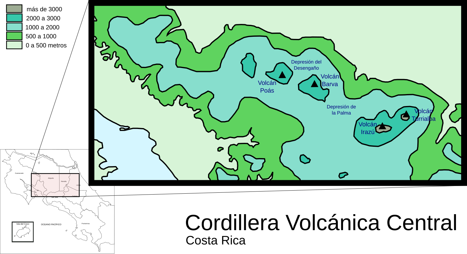
| Description | Mapa y localización de la cordillera volcánica central, Costa Rica. |
| Date | 10/04/2007 |
| Source | Own work |
| Author | Shamhain |
Licensing[edit]
I, the copyright holder of this work, hereby publish it under the following licenses:

|
Permission is granted to copy, distribute and/or modify this document under the terms of the GNU Free Documentation License, Version 1.2 or any later version published by the Free Software Foundation; with no Invariant Sections, no Front-Cover Texts, and no Back-Cover Texts. A copy of the license is included in the section entitled GNU Free Documentation License. |
This file is licensed under the Creative Commons Attribution-Share Alike 3.0 Unported, 2.5 Generic, 2.0 Generic and 1.0 Generic license.
- You are free:
- to share – to copy, distribute and transmit the work
- to remix – to adapt the work
- Under the following conditions:
- attribution – You must give appropriate credit, provide a link to the license, and indicate if changes were made. You may do so in any reasonable manner, but not in any way that suggests the licensor endorses you or your use.
- share alike – If you remix, transform, or build upon the material, you must distribute your contributions under the same or compatible license as the original.
You may select the license of your choice.
File history
Click on a date/time to view the file as it appeared at that time.
| Date/Time | Thumbnail | Dimensions | User | Comment | |
|---|---|---|---|---|---|
| current | 13:41, 2 October 2023 | | 1,522 × 828 (181 KB) | Gvilasecaj (talk | contribs) | File uploaded using svgtranslate tool (https://svgtranslate.toolforge.org/). Added translation for ca. |
| 22:38, 4 September 2007 |  | 1,522 × 828 (175 KB) | Shamhain (talk | contribs) | {{Information |Description= Mapa y localización de la cordillera volcánica central, Costa Rica. |Source= self-made |Date= 10/04/2007 |Author= Shamhain }} |
You cannot overwrite this file.
File usage on Commons
The following 2 pages use this file:
File usage on other wikis
The following other wikis use this file:
- Usage on ca.wikipedia.org
- Usage on ceb.wikipedia.org
- Usage on en.wikipedia.org
- Usage on es.wikipedia.org
- Usage on it.wikipedia.org
- Usage on pt.wikipedia.org
- Usage on sl.wikipedia.org
- Usage on sv.wikipedia.org
- Usage on www.wikidata.org