File:Map showing route of Norfolk & Petersburg Rail Road and its connections with Ohio & Mississippi Rivers, William Mahone, Chief Engineer, F. Bourquin & Co., Philada. LOC 98688739.jpg
Jump to navigation
Jump to search

Size of this preview: 800 × 460 pixels. Other resolutions: 320 × 184 pixels | 640 × 368 pixels | 1,024 × 589 pixels | 1,280 × 736 pixels | 2,560 × 1,472 pixels | 14,071 × 8,089 pixels.
Original file (14,071 × 8,089 pixels, file size: 10.17 MB, MIME type: image/jpeg)
Captions
Captions
Add a one-line explanation of what this file represents
Summary[edit]
| Warning | The original file is very high-resolution. It might not load properly or could cause your browser to freeze when opened at full size. |
|---|
| Description |
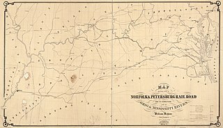
English: Map of the eastern United States between the Chesapeake Bay and the Mississippi River. Shows drainage, place names and the railroad network. Chartered March 17, 1851. Line completed in 1858. consolidated in April 1871, forming part of the Atlantic, Mississippi, and Ohio Railroad. |
||
| Title | Map showing route of Norfolk & Petersburg Rail Road and its connections with Ohio & Mississippi Rivers, William Mahone, Chief Engineer, F. Bourquin & Co., Philada. | ||
| Shelf ID | G3701.P3 1858 .M3 | ||
| Date | |||
| Source | https://www.loc.gov/item/98688739/ | ||
| Author | Mahone, William; Norfolk And Petersburg Railroad Company | ||
| Permission (Reusing this file) |
|
||
| Other versions |
|
||
| Location | United States | ||
| Part of | American Memory · Catalog · Railroad Maps, 1828-1900 · Geography And Map Division · Transportation And Communication | ||
| Subject | United States · Norfolk And Petersburg Railroad Company · Railroads · Maps |


Licensing[edit]
|
This is a faithful photographic reproduction of a two-dimensional, public domain work of art. The work of art itself is in the public domain for the following reason:
The official position taken by the Wikimedia Foundation is that "faithful reproductions of two-dimensional public domain works of art are public domain".
This photographic reproduction is therefore also considered to be in the public domain in the United States. In other jurisdictions, re-use of this content may be restricted; see Reuse of PD-Art photographs for details. | ||||
File history
Click on a date/time to view the file as it appeared at that time.
| Date/Time | Thumbnail | Dimensions | User | Comment | |
|---|---|---|---|---|---|
| current | 11:49, 30 May 2018 | | 14,071 × 8,089 (10.17 MB) | Fæ (talk | contribs) | LOC Maps https://www.loc.gov/item/98688739/ #34 |
You cannot overwrite this file.
File usage on Commons
The following page uses this file: