File:Map showing flight path of Qantas Flight 32 on 4 November 2010.png
Jump to navigation
Jump to search
No higher resolution available.
Map_showing_flight_path_of_Qantas_Flight_32_on_4_November_2010.png (252 × 271 pixels, file size: 39 KB, MIME type: image/png)
Captions
Captions
Add a one-line explanation of what this file represents
Summary[edit]
| Description |
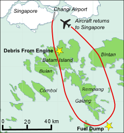
English: A map showing the flight path of Qantas Flight 32 on 4 November 2010 when it suffered a turbine engine failure and made an emergency landing at Singapore Changi Airport. The failure was the first of its kind for the four-engined Airbus A380. |
| Date | 5 November 2010 (original upload date). |
| Source | Own work; partly derived from File:Batam.png. |
| Author | Advanstra. |
Licensing[edit]
This file is licensed under the Creative Commons Attribution-Share Alike 3.0 Unported license.
- You are free:
- to share – to copy, distribute and transmit the work
- to remix – to adapt the work
- Under the following conditions:
- attribution – You must give appropriate credit, provide a link to the license, and indicate if changes were made. You may do so in any reasonable manner, but not in any way that suggests the licensor endorses you or your use.
- share alike – If you remix, transform, or build upon the material, you must distribute your contributions under the same or compatible license as the original.
File history
Click on a date/time to view the file as it appeared at that time.
| Date/Time | Thumbnail | Dimensions | User | Comment | |
|---|---|---|---|---|---|
| current | 22:55, 10 August 2019 | | 252 × 271 (39 KB) | High source (talk | contribs) | km map |
| 02:56, 5 November 2010 |  | 252 × 271 (42 KB) | Advanstra (talk | contribs) | Flight path of QF32 and location of events Category:Singapore Changi Airport Category:Aviation accidents in Indonesia Category:Qantas |
You cannot overwrite this file.
File usage on Commons
The following 5 pages use this file:
File usage on other wikis
The following other wikis use this file:
- Usage on en.wikipedia.org
- Usage on fr.wikipedia.org
- Usage on he.wikipedia.org
- Usage on pt.wikipedia.org
- Usage on ru.wikipedia.org