File:Map showing Schouten and Le Maire’s route across the Pacific Ocean from Cape Horn on the Eendracht. (Amsterdam, 1619).jpg
Jump to navigation
Jump to search

Size of this preview: 800 × 340 pixels. Other resolutions: 320 × 136 pixels | 640 × 272 pixels | 1,024 × 436 pixels | 1,280 × 545 pixels | 4,146 × 1,764 pixels.
Original file (4,146 × 1,764 pixels, file size: 3.31 MB, MIME type: image/jpeg)
Captions
Captions
Add a one-line explanation of what this file represents
Summary[edit]
.jpg&action=edit§ion=1)
| Description |
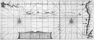
English: Map showing Schouten and Le Maire’s route across the Pacific Ocean from Cape Horn on the Eendracht in 1616. From Schouten’s Diarium vel descriptio laboriosissimi, & molestissimi itineris . . . (Amsterdam, 1619). It is the first map to show, among others, the island of Futuna, Alofi (named Hoornſe Eylanden), Niuafo'ou (Eylant van goede hope), Tafahi (Cocos Eylant) and Niuatoputapu (Verraders Eylant).
The legend is written in (middle) Dutch, (middle) French and Latin.
Français : Carte montrant le trajet parcouru par Willem Schouten et Jacob Le Maire en 1616 dans le Pacifique depuis le Cap Horn à bord de l'Eendracht. Carte extraite du Diarium vel descriptio laboriosissimi, & molestissimi itineris . . . de Schouten (Amsterdam, 1619). Il s'agit de la première carte montrant les îles de Futuna, Alofi (ici Hoornſe Eylanden), Niuafo'ou (Eylant van goede hope), Tafahi (Cocos Eylant) and Niuatoputapu (Verraders Eylant).
La légende de la carte est écrite en (moyen) néerlandais, (moyen) français et latin.
|
| Date | |
| Source | https://libweb5.princeton.edu/visual_materials/maps/websites/pacific/maire-schouten/maire-schouten.html |
| Author | Willem Schouten |
Licensing[edit]
.jpg&action=edit§ion=2)
|
This work is in the public domain in its country of origin and other countries and areas where the copyright term is the author's life plus 70 years or fewer. This work is in the public domain in the United States because it was published (or registered with the U.S. Copyright Office) before January 1, 1929. | |
| This file has been identified as being free of known restrictions under copyright law, including all related and neighboring rights. | |
File history
Click on a date/time to view the file as it appeared at that time.
| Date/Time | Thumbnail | Dimensions | User | Comment | |
|---|---|---|---|---|---|
| current | 10:53, 2 November 2016 | | 4,146 × 1,764 (3.31 MB) | Skimel (talk | contribs) | User created page with UploadWizard |
You cannot overwrite this file.
File usage on Commons
The following 2 pages use this file:
File usage on other wikis
The following other wikis use this file:
- Usage on fr.wikipedia.org
.jpg&oldid=737651742)