File:Map of tropical cyclone affected areas.png
Jump to navigation
Jump to search

Size of this preview: 800 × 371 pixels. Other resolutions: 320 × 148 pixels | 640 × 296 pixels | 1,347 × 624 pixels.
Original file (1,347 × 624 pixels, file size: 94 KB, MIME type: image/png)
Captions
Captions
Add a one-line explanation of what this file represents
| Description |
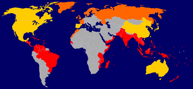
A map of tropical cyclone affected areas. Based off Image:BlankMap-World-v5.png and overlaid with Image:Ocean-layer BlankMap-World.png. Information based mainly off Image:Global tropical cyclone tracks.jpg. Fully-tropical cyclones have affected these nations/territories.
Both fully-tropical cyclones, as well as extratropical remnants of tropical cyclones, have affected these areas.
Extratropical remnants of tropical cyclones have affected these areas.
This is by no means a fully-complete map, and may contain errors. |
||||||||
| Date |
2006-09-29 Updated: 2006-09-30 Updated: 2006-12-23 Updated: 2007-04-09 |
||||||||
| Source | Self-work | ||||||||
| Author | User:NSLE-Chacor | ||||||||
| Permission (Reusing this file) |
|

File history
Click on a date/time to view the file as it appeared at that time.
| Date/Time | Thumbnail | Dimensions | User | Comment | |
|---|---|---|---|---|---|
| current | 16:08, 9 April 2007 | | 1,347 × 624 (94 KB) | NSLE-Chacor (talk | contribs) | Background changed to blue, Panama back to red |
| 12:19, 23 December 2006 |  | 1,347 × 624 (93 KB) | NSLE-Chacor (talk | contribs) | Further update using Image:Global tropical cyclone tracks.jpg - two countries changed to grey (unaffected), Senegal added in tropical | |
| 12:08, 23 December 2006 |  | 1,347 × 624 (93 KB) | NSLE-Chacor (talk | contribs) | Fixed stray blues not changed in colour scheme change | |
| 12:06, 23 December 2006 |  | 1,347 × 624 (93 KB) | NSLE-Chacor (talk | contribs) | update: Colour change, Mexico, Bahamas and Taiwan to both tropical and extratropical | |
| 05:04, 30 September 2006 |  | 1,347 × 624 (130 KB) | NSLE-Chacor (talk | contribs) | Update: Denmark changed to green (Faeroe Islands affected by w:Hurricane Faith while tropical); Australia changed to green (extratropical remnants recorded). | |
| 06:15, 29 September 2006 |  | 1,347 × 624 (130 KB) | NSLE-Chacor (talk | contribs) | {{Information |Description= A map of tropical cyclone affected areas. Based off Image:BlankMap-World-v5.png and overlaid with Image:Ocean-layer BlankMap-World.png. Aqua-coloured nations/territories indicate that fully-tropical cyclones have affe |
You cannot overwrite this file.
File usage on Commons
There are no pages that use this file.
File usage on other wikis
The following other wikis use this file:
- Usage on el.wikipedia.org
- Usage on en.wikipedia.org
- Usage on ml.wikipedia.org
- Usage on pt.wikipedia.org
Categories:
- Cumulative tropical cyclone tracks
- Maps of weather forecast and climate prediction
- Mean meteorological data of the world
- Maps of the world without Antarctica
- Mean meteorological data of the United States
- Mean meteorological data of Denmark
- Mean meteorological data of Norway
- Mean meteorological data of Sweden
- Mean meteorological data of Africa
- Mean meteorological data of the Netherlands
- Maps of weather impact areas
- Tropical cyclone damage