File:Map of the world oceans, October 2012. LOC 2013591571.jpg
Jump to navigation
Jump to search

Size of this preview: 800 × 450 pixels. Other resolutions: 320 × 180 pixels | 640 × 360 pixels | 1,024 × 576 pixels | 1,280 × 720 pixels | 2,560 × 1,440 pixels | 11,646 × 6,551 pixels.
Original file (11,646 × 6,551 pixels, file size: 9.79 MB, MIME type: image/jpeg)
Captions
Captions
Add a one-line explanation of what this file represents
Summary[edit]
| Description |
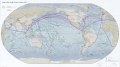
English: Relief shown by shading. Depths shown by shading. Shows shipping lanes and major ports. "October 2012." "803518AI (G03545) 10-12." Includes notes. Available also through the Library of Congress Web site as a raster image. |
||
| Title | Map of the world oceans, October 2012. | ||
| Shelf ID | G3201.P54 2012 .U5 | ||
| Date | |||
| Source | https://www.loc.gov/item/2013591571/ | ||
| Author | United States. Central Intelligence Agency | ||
| Permission (Reusing this file) |
|
||
| Other versions |
|
||
| Location | Planet · Earth (Planet) · Earth | ||
| Part of | American Memory · Catalog · Transportation And Communication · Geography And Map Division | ||
| Subject | Physical Maps · World Maps · Shipping · Maps · Earth (Planet) · Harbors |

Licensing[edit]
| This image is a work of a Central Intelligence Agency employee, taken or made as part of that person's official duties. As a Work of the United States Government, this image or media is in the public domain in the United States.
|

|
File history
Click on a date/time to view the file as it appeared at that time.
| Date/Time | Thumbnail | Dimensions | User | Comment | |
|---|---|---|---|---|---|
| current | 10:33, 20 May 2018 | | 11,646 × 6,551 (9.79 MB) | Fæ (talk | contribs) | LOC Maps https://www.loc.gov/item/2013591571/ #12234 |
You cannot overwrite this file.
File usage on Commons
The following page uses this file: