File:Map of the all American Route showing proposed railroad and U.S. Government Mail Road to the Yukon; issued by Central Alaska Transportation & Trading Co.; compiled by B. F. Millard and Emil Mahlo, LOC 98688442.jpg
Jump to navigation
Jump to search

Size of this preview: 563 × 600 pixels. Other resolutions: 225 × 240 pixels | 450 × 480 pixels | 721 × 768 pixels | 961 × 1,024 pixels | 1,922 × 2,048 pixels | 6,216 × 6,624 pixels.
Original file (6,216 × 6,624 pixels, file size: 7.13 MB, MIME type: image/jpeg)
Captions
Captions
Add a one-line explanation of what this file represents
Summary[edit]
| Description |
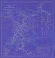
English: Map of central Alaska showing relief by hachures and spot heights, drainage, glaciers, cities and towns, international boundary, trails and the proposed railroad. |
||
| Title | Map of the all American Route showing proposed railroad and U.S. Government Mail Road to the Yukon; issued by Central Alaska Transportation & Trading Co.; compiled by B. F. Millard and Emil Mahlo, Topographical Engineer, U.S. Alaska Exploration Expedition Capt. W.A. Abercrombie, U.S.A. Commanding. | ||
| Shelf ID | G4371.P3 1899 .M5 | ||
| Date | |||
| Source | https://www.loc.gov/item/98688442/ | ||
| Author | Millard, F.; Mahlo, Emil | ||
| Permission (Reusing this file) |
|
||
| Other versions |
|
||
| Location | United States · Alaska | ||
| Part of | American Memory · Catalog · Railroad Maps, 1828-1900 · Geography And Map Division · Transportation And Communication | ||
| Subject | United States · Maps · Railroads · Alaska |

Licensing[edit]
|
This is a faithful photographic reproduction of a two-dimensional, public domain work of art. The work of art itself is in the public domain for the following reason:
The official position taken by the Wikimedia Foundation is that "faithful reproductions of two-dimensional public domain works of art are public domain".
This photographic reproduction is therefore also considered to be in the public domain in the United States. In other jurisdictions, re-use of this content may be restricted; see Reuse of PD-Art photographs for details. | ||||
File history
Click on a date/time to view the file as it appeared at that time.
| Date/Time | Thumbnail | Dimensions | User | Comment | |
|---|---|---|---|---|---|
| current | 03:32, 31 May 2018 | | 6,216 × 6,624 (7.13 MB) | Fæ (talk | contribs) | LOC Maps https://www.loc.gov/item/98688442/ #15871 |
You cannot overwrite this file.
File usage on Commons
The following 2 pages use this file: