File:Map of the RER Bruxelles - GEN Brussels.png
Jump to navigation
Jump to search

Size of this preview: 779 × 600 pixels. Other resolutions: 312 × 240 pixels | 623 × 480 pixels | 997 × 768 pixels | 1,280 × 986 pixels | 2,560 × 1,972 pixels | 2,746 × 2,115 pixels.
Original file (2,746 × 2,115 pixels, file size: 7.03 MB, MIME type: image/png)
Captions
Captions
Add a one-line explanation of what this file represents
Summary[edit]
| Description |
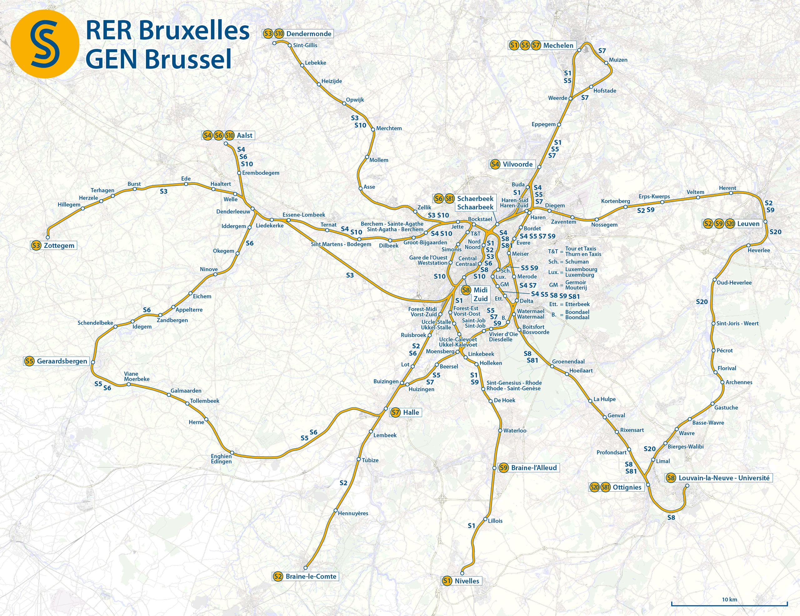
Deutsch: Karte der S-Bahn Brüssel
English: Map of the Brussels Regional Express Network
Français : Carte du Réseau express régional bruxellois (RER bruxellois, Train S)]]
Nederlands: Kaart van de Gewestelijk ExpresNet Brussel (GEN Brussel, S-Trein) |
|||
| Date | see file history | |||
| Source | Own work, using OpenStreetMap data for the background | |||
| Author | Maximilian Dörrbecker (Chumwa) | |||
| Permission (Reusing this file) |
This file is licensed under the Creative Commons Attribution-Share Alike 2.0 Generic license.
|

|
This map image could be re-created using vector graphics as an SVG file. This has several advantages; see Commons:Media for cleanup for more information. If an SVG form of this image is available, please upload it and afterwards replace this template with
{{vector version available|new image name}}.
It is recommended to name the SVG file “Map of the RER Bruxelles - GEN Brussels.svg”—then the template Vector version available (or Vva) does not need the new image name parameter. |
File history
Click on a date/time to view the file as it appeared at that time.
| Date/Time | Thumbnail | Dimensions | User | Comment | |
|---|---|---|---|---|---|
| current | 06:12, 9 February 2016 | | 2,746 × 2,115 (7.03 MB) | Chumwa (talk | contribs) | |
| 21:10, 8 February 2016 |  | 2,746 × 2,115 (7.44 MB) | Chumwa (talk | contribs) | ||
| 09:43, 7 February 2016 |  | 2,746 × 2,115 (7.03 MB) | Chumwa (talk | contribs) | == {{int:filedesc}} == {{Information |Description = {{de|1=Karte der S-Bahn Brüssel}} {{en|1=Map of the Brussels Regional Express Network}} {{fr|1=Carte du Réseau express régional bruxellois (RER bruxellois, Train S)]]}} {{nl|1=Kaart van de Gewes... |
You cannot overwrite this file.
File usage on Commons
The following 7 pages use this file:
- User:Chumwa/Gallery
- User:Chumwa/OgreBot/Potential transport maps/2016 February 1-9
- User:Chumwa/OgreBot/Public transport information/2016 February 1-9
- User:Chumwa/OgreBot/Transport Maps/2016 February 1-9
- User:Chumwa/OgreBot/Travel and communication maps/2016 February 1-9
- User:Chumwa/Railway maps
- Category:Brussels Regional Express Network
File usage on other wikis
The following other wikis use this file:
- Usage on de.wikipedia.org
- Usage on de.wikivoyage.org
- Usage on en.wikipedia.org
- Usage on eu.wikipedia.org
- Usage on fr.wikipedia.org
- Usage on it.wikipedia.org
- Usage on nl.wikipedia.org
- Usage on pl.wikipedia.org
- Usage on ro.wikipedia.org
- Usage on ru.wikipedia.org
- Usage on www.wikidata.org
- Usage on zh.wikipedia.org