File:Map of the Old Colony Rail Road with its branches & connecting roads, prepared under the direction of the Committee of Investigation, Jany. 1850, S. Dwight Eaton, Engr. LOC 98688753.jpg
Jump to navigation
Jump to search

Size of this preview: 427 × 600 pixels. Other resolutions: 171 × 240 pixels | 342 × 480 pixels | 547 × 768 pixels | 729 × 1,024 pixels | 1,458 × 2,048 pixels | 6,080 × 8,538 pixels.
Original file (6,080 × 8,538 pixels, file size: 6.95 MB, MIME type: image/jpeg)
Captions
Captions
Add a one-line explanation of what this file represents
Summary[edit]
| Description |
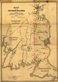
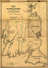
English: Map of eastern Massachusetts covering the area from Boston to Wood's Hole and west to Providence, R.I. Shows drainage, place names and counties, and indicates mileage between stations. The Old Colony Railroad is double-tracked from Boston, south to South Braintree. The line was incorporated in 1844. |
||
| Title | Map of the Old Colony Rail Road with its branches & connecting roads, prepared under the direction of the Committee of Investigation, Jany. 1850, S. Dwight Eaton, Engr. | ||
| Shelf ID | G3761.P3 1850 .F4 | ||
| Date | |||
| Source | https://www.loc.gov/item/98688753/ | ||
| Author | Ferguson, W. E.; Old Colony Railroad Company | ||
| Permission (Reusing this file) |
|
||
| Other versions |
|
||
| Location | United States · Massachusetts | ||
| Part of | American Memory · Catalog · Railroad Maps, 1828-1900 · Geography And Map Division · Transportation And Communication | ||
| Subject | United States · Maps · Railroads · Old Colony Railroad Company · Massachusetts |

Licensing[edit]
|
This is a faithful photographic reproduction of a two-dimensional, public domain work of art. The work of art itself is in the public domain for the following reason:
The official position taken by the Wikimedia Foundation is that "faithful reproductions of two-dimensional public domain works of art are public domain".
This photographic reproduction is therefore also considered to be in the public domain in the United States. In other jurisdictions, re-use of this content may be restricted; see Reuse of PD-Art photographs for details. | ||||
File history
Click on a date/time to view the file as it appeared at that time.
| Date/Time | Thumbnail | Dimensions | User | Comment | |
|---|---|---|---|---|---|
| current | 09:46, 11 June 2018 | | 6,080 × 8,538 (6.95 MB) | Fæ (talk | contribs) | LOC Maps https://www.loc.gov/item/98688753/ #11715 |
You cannot overwrite this file.
File usage on Commons
The following page uses this file: